Garforth is a town in east Leeds with strong rail connections, established walking routes, local facilities and access to surrounding countryside. Its location makes it practical for a lower-impact day visit based around walking, public transport, cycling and carefully planned local journeys.
- What makes Garforth suitable for a sustainable local visit?
- How should you travel to Garforth without a car?
- Which Garforth railway station should you use?
- How can you explore Garforth on foot?
- How can The Linesway be included in a sustainable Garforth itinerary?
- What walking routes near Garforth are suitable for different visit lengths?
- Can cycling make a Garforth visit more sustainable?
- How should visitors plan a lower-impact day in Garforth?
- How can visitors reduce waste and environmental impact during a Garforth visit?
- How can public transport make a Garforth visit more sustainable?
- What should a sustainable Garforth itinerary look like?
- Why is sustainable travel important for Garforth’s future?
A sustainable visit does not require visitors to avoid transport completely. It means choosing the most suitable lower-impact option for each part of the journey. Garforth provides several opportunities to arrive by train, continue on foot, use local public transport, cycle where suitable and combine several activities within one visit.
The town also sits within a wider network of paths and countryside routes. The Lines Way, Leeds Country Way and surrounding public rights of way create opportunities to explore beyond the central streets without relying on a car. Leeds City Council identifies walking, cycling, wheeling, public transport and shared transport as sustainable travel modes.
For visitors, this makes Garforth suitable for a slower local itinerary. A sustainable visit can begin at a railway station, continue through the town centre, include a café or community facility, and extend into nearby green space before returning to the station.
What makes Garforth suitable for a sustainable local visit?
Garforth supports sustainable visits through two railway stations, walking routes, public rights of way, local facilities and access to surrounding countryside, allowing visitors to reduce unnecessary car journeys while combining transport, leisure, food and outdoor activities within one local itinerary.
The main advantage is connectivity. Garforth has Garforth railway station and East Garforth railway station, both served by rail services connecting the area with Leeds and destinations towards York and beyond. Northern lists Garforth on services including routes between Leeds and York.
Walking provides the second major component. Leeds City Council lists The Linesway as a three-mile route along a disused railway between Garforth and Allerton Bywater. The route provides a defined opportunity to include active travel within a local visit.
The Leeds Country Way also passes through Garforth. The official route information identifies a 5.5-mile section from Barwick-in-Elmet to Garforth and another 5.5-mile section from Garforth towards the River Aire.
The combination of rail and walking means visitors can plan an itinerary without making the car the central part of the journey. A visitor arriving by train can spend the day locally rather than driving between separate attractions.
Garforth’s neighbourhood planning documents also identify sustainable travel, pedestrian and cycle provision, public rights of way, countryside access and the protection of the Lines Way as important elements of the town’s future connectivity.
This gives sustainable travel a practical local foundation rather than making it simply an environmental choice.
How should you travel to Garforth without a car?
Travelling to Garforth without a car is straightforward when visitors use rail as the main transport mode and complete local journeys on foot, by suitable cycle routes or by public transport, reducing the need for private-car travel between activities during the visit.
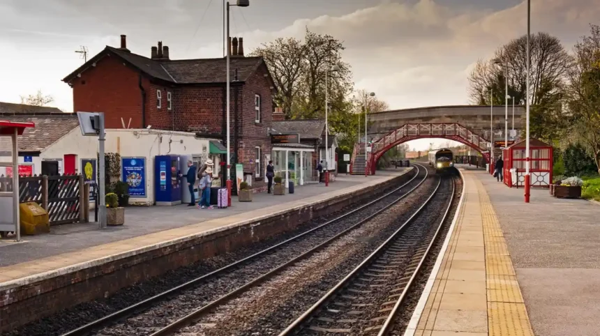
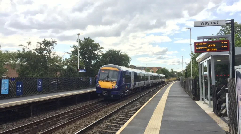
Rail is the most useful starting point for many visitors travelling from Leeds and other connected locations. Garforth station has a staffed ticket office during listed hours, ticket machines, a car park and cycle facilities. Northern also records step-free access to the platforms from the main entrance on Station Road.
East Garforth provides another rail access point. Northern records ramped access to both platforms at East Garforth, although the station has fewer facilities than Garforth station.
Visitors should check the current timetable before travelling because service patterns change according to engineering works, seasonal timetables and operational requirements. Northern publishes current journey information and timetable details for Garforth and East Garforth.
Once in Garforth, walking is appropriate for many short journeys. This is particularly useful when the day’s activities are grouped geographically. Instead of returning to a car after every stop, visitors can build a route that connects the station, shops, cafés, community facilities and walking paths.
For longer local journeys, visitors should check current West Yorkshire public transport information before departure. Leeds City Council directs travellers towards bus and train journey information and Metro services for planning public transport journeys across the area.
The practical principle is simple: use rail for the regional journey, walking for short local journeys and public transport where walking distances become unsuitable.
Which Garforth railway station should you use?
Garforth railway station is the stronger choice for visitors needing more facilities, while East Garforth provides another rail access point with ramped platform access; the best station depends on the itinerary, walking direction, accessibility requirements and the current train timetable.
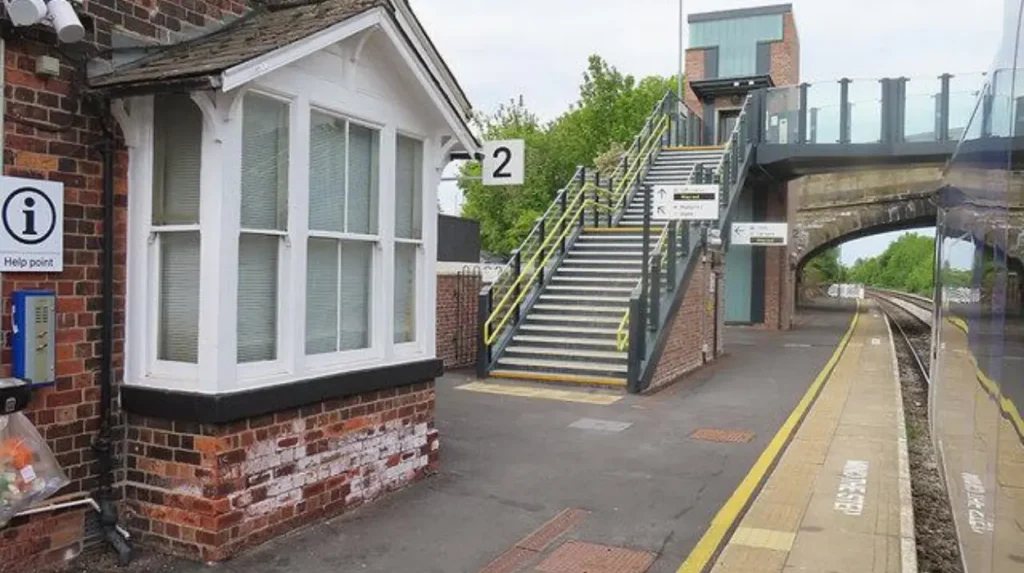
Garforth station is located on Station Road and has access to both platforms through the station entrance and footbridge arrangements. Northern records step-free platform access from the main entrance, while the secondary Aberford Road entrance has restrictions for wheelchair and mobility scooter users.
The station also has nine bicycle spaces, with sheltered facilities recorded by Northern. This gives cyclists an additional option for combining rail and active travel.
East Garforth is a more limited station but has ramped access to both platforms. Northern records no station car park and no bicycle spaces at East Garforth.
Station choice therefore depends on the destination within Garforth. Visitors planning a walking route should examine the route from each station rather than assuming that one station is always better.
Accessibility also requires advance planning. Station facilities, engineering works and temporary arrangements can change. Visitors with mobility requirements should check the latest operator information before travelling and allow additional time where necessary.
For a visit centred on walking, the best arrival station is the one that places the visitor closest to the intended first activity and avoids unnecessary backtracking. This reduces both walking distance and the need for additional transport.
How can you explore Garforth on foot?
Garforth can be explored on foot by combining town-centre streets with established public rights of way and longer routes such as The Linesway and Leeds Country Way, allowing visitors to connect local facilities with countryside without depending on private transport.
Walking is one of the simplest ways to make a Garforth visit lower impact. It also allows visitors to connect several short activities into one continuous route.
The Linesway is particularly relevant. Leeds City Council describes it as a three-mile disused railway route between Garforth and Allerton Bywater. Its former railway alignment gives it a distinct role within the local walking network.
The route also forms part of the wider Garforth-to-River Aire section of the Leeds Country Way. Leeds City Council’s route description directs walkers from Garforth along the old railway line, now called the Linesway, before continuing towards Brecks Wood and the River Aire.
Visitors do not need to complete an entire long-distance route. A shorter out-and-back walk provides a flexible option for visitors with limited time.
The wider Leeds Country Way is a 62-mile circular walking route around Leeds. The Garforth sections show how the town connects directly with the wider countryside network.
Walkers should remain on designated paths, follow signs and respect private land, agricultural operations and other path users. Weather conditions also affect walking surfaces, particularly on unsurfaced countryside sections.
Comfortable footwear is important because routes can include pavements, tracks, field paths and uneven ground. Visitors should also carry water and check daylight hours when planning longer walks.
The sustainable advantage is clear. A visitor can arrive by train, walk to a local café, continue onto a public right of way and return to the station without starting a car journey between each activity.
How can The Linesway be included in a sustainable Garforth itinerary?
The Linesway works well as the outdoor section of a sustainable Garforth itinerary because it connects the town with a former railway corridor and wider walking network, providing a practical way to add countryside and active travel without requiring a private vehicle.
The Linesway is one of Garforth’s most useful assets for visitors interested in active travel. Leeds City Council records it as a three-mile disused railway route between Garforth and Allerton Bywater.
Its former railway function is also relevant to the history of the landscape. The route demonstrates how infrastructure that once served rail transport now contributes to walking connectivity.
As you explore the modern route, you are crossing land with a deep heritage. Read about the full [Garforth railway and transport history] to understand its origins.
A sustainable itinerary can use The Linesway as either the main activity or one part of a wider day. A visitor with several hours can combine a town-centre stop with a walk. A visitor with more time can continue further along the route and return by the same general corridor.
The route is also useful for understanding the relationship between Garforth and surrounding settlements. Its connection towards Allerton Bywater demonstrates that local walking infrastructure extends beyond the immediate town boundary.
Visitors should check the current route condition before setting out. Former railway paths can include variable surfaces, crossings and changing weather conditions. Cyclists and walkers should share the space responsibly where routes support multiple users.
The Linesway should not be treated simply as a shortcut. It is part of the local recreational network and provides a way to experience the landscape while keeping private-car use out of the centre of the itinerary.
What walking routes near Garforth are suitable for different visit lengths?
Short visits can use local streets and short sections of walking paths, half-day visits can incorporate The Linesway, and longer outings can use sections of Leeds Country Way, giving visitors flexible sustainable options without requiring one fixed route or travel style.
Route length should match the visitor’s available time and physical ability. Sustainable travel works best when the itinerary is realistic.
For a short visit, a station-to-town walking route provides the simplest structure. The visitor can arrive by rail, explore local facilities and return to the station on foot.
For a half-day visit, The Linesway provides a stronger outdoor component. Leeds City Council records the route as three miles between Garforth and Allerton Bywater, making it suitable for visitors seeking a more substantial walk.
For longer walks, the Leeds Country Way offers additional options. The official route information identifies a 5.5-mile Garforth section towards Barwick-in-Elmet and another 5.5-mile section from Garforth towards the River Aire.
These distances should not be interpreted as requirements. Visitors can use sections of the routes according to time, fitness and weather.
A digital map is useful for checking the position of the route, nearby roads and return options. Visitors should also identify the location of their intended rail station before starting a longer walk.
The most efficient itinerary is often a linear journey rather than a collection of separate destinations. For example, a visitor can arrive at Garforth station, walk through the town and continue towards a countryside route before returning towards the station.
This approach reduces unnecessary transport changes and creates a more coherent day.
Can cycling make a Garforth visit more sustainable?
Cycling can reduce reliance on private cars for longer local journeys, particularly when visitors combine rail and cycling, although cyclists should select suitable routes, check current conditions and use secure bicycle facilities where available before starting their Garforth itinerary.
Cycling is recognised by Leeds City Council as a sustainable travel mode alongside walking, wheeling, public transport and shared transport.
Rail and cycling can work together particularly well when the cycling destination is beyond comfortable walking distance. Garforth station has nine bicycle spaces, including sheltered provision, according to Northern’s current station information.
East Garforth has no bicycle spaces listed by Northern, so visitors planning to leave a bicycle at a station should check the relevant facilities before travelling.
Cyclists should distinguish between recreational paths and routes designed for everyday cycling. A walking route is not automatically suitable for every type of bicycle or rider.
The Linesway forms part of the local active-travel network, but visitors should follow signs, give way where required and consider pedestrians when cycling.
Leeds City Council also operates wider cycling initiatives across the city, including shared mobility services in suitable areas. Availability is location-specific, so visitors should check current service coverage rather than assuming that hire bicycles or scooters operate in Garforth.
For visitors bringing their own bicycle, the most sustainable approach is to plan the entire route before departure. This includes checking the rail operator’s bicycle conditions, identifying suitable roads or paths and confirming the return journey.
How should visitors plan a lower-impact day in Garforth?
A lower-impact Garforth day should combine one regional public-transport journey with several local activities reached on foot, cycling or public transport, while avoiding unnecessary vehicle movements and choosing routes that connect naturally rather than requiring repeated returns to a car.
The first step is to choose the day’s main purpose. A walking-focused visit requires different planning from a café-based visit, a family outing or a short business trip.
The second step is to select the arrival station. Visitors should compare Garforth and East Garforth according to their final destination and accessibility requirements.
The third step is to group activities geographically. A sustainable itinerary works better when visitors move progressively through an area rather than travelling repeatedly between separate points.
For example, a visitor can arrive by train, walk into the local area, stop for breakfast or coffee, continue to a walking route and return towards the railway station later in the day. The exact businesses selected can change, but the travel principle remains the same.
Food planning also affects transport. Choosing local cafés and shops during a walking itinerary reduces the need to travel elsewhere for refreshments.
For digital nomads and business travellers, the same principle applies. A work session can be scheduled around a local café or suitable public facility, followed by a short walking route during a break. Garforth Leisure Centre, for example, provides free Wi-Fi alongside gym, studio, squash and badminton facilities, although visitors should check current access arrangements before relying on it as a workspace.
Visitors should also plan their return journey before starting a long walk. This is particularly important when the final activity is outside the town centre.
Leeds City Council recommends walking, cycling or scooting for short journeys and using bus or rail for longer journeys as part of reducing travel emissions.
The result is a practical travel pattern: one efficient arrival, several connected local activities and one planned return journey.
How can visitors reduce waste and environmental impact during a Garforth visit?
Visitors can reduce environmental impact by carrying reusable water bottles, avoiding unnecessary packaging, using refill opportunities where available, disposing of waste responsibly and staying on designated routes to protect paths, vegetation, wildlife and agricultural land around Garforth.
Sustainable travel is only one part of responsible local tourism. Visitor behaviour at the destination also affects the environment.
Walking routes pass through different landscapes, including streets, former railway corridors, fields and countryside. Visitors should use established paths rather than creating informal shortcuts across vegetation or agricultural land.
Litter should be carried until a suitable bin is available when no disposal point exists. Food packaging creates unnecessary environmental pressure when it is left on paths or in green spaces.
Reusable containers provide a straightforward way to reduce disposable packaging. Visitors should also plan food purchases according to the length of the walk, particularly on longer rural routes where shops and facilities are less frequent.
Noise should be kept at a reasonable level in residential and countryside areas. Dogs should remain under control and visitors should follow local signage relating to livestock and access.
Leeds planning policy for Garforth places importance on public rights of way, countryside access, green infrastructure, biodiversity, tree cover and hedgerows. The neighbourhood plan specifically supports maintaining access to surrounding countryside and protecting wildlife corridors.
This makes responsible behaviour particularly relevant to the area’s long-term sustainability.
Visitors should also respect local residents. Sustainable tourism is not simply about carbon emissions. It includes maintaining clean public spaces, protecting shared routes and ensuring that visitor activity does not create avoidable disruption.
How can public transport make a Garforth visit more sustainable?
Public transport reduces the need for individual car journeys and gives visitors a practical way to connect Garforth with Leeds and the wider rail network, while walking and cycling provide lower-impact options for completing shorter journeys after arrival.
Public transport is central to Leeds’ sustainable travel strategy. Leeds City Council identifies public transport alongside walking, cycling, wheeling and shared transport as sustainable modes.
Rail is particularly useful for Garforth because the town has two stations. Northern publishes station information, facilities and timetable details for both Garforth and East Garforth.
Visitors travelling from Leeds can therefore avoid driving into Garforth and parking for the entire day. The same principle applies in reverse for visitors based in Garforth who want to explore Leeds without using a private car.
Bus services provide another option for journeys not conveniently served by rail. Current routes and timetables should be checked before departure because services can change.
A sustainable transport plan should always include contingency arrangements. Engineering works, delays and weather conditions can affect rail and bus services. Visitors should check live travel information on the day of travel.
Public transport also creates a natural structure for a day trip. The visitor has a defined arrival point and departure point, encouraging a walkable itinerary rather than dispersed car-based travel.
For business travellers, this approach can make short periods of free time more productive. A train journey can remove the need to find parking, while a walk between local activities provides active travel without requiring additional transport.
The objective is not to eliminate cars from every journey. It is to use the most appropriate transport mode for each stage and avoid journeys that add distance without adding value.
Explore More Area Guide
Garforth Weekend Morning: Relaxed Places to Explore in Leeds
Garforth Recreation Guide: Adult Leisure and Activities in Leeds
What should a sustainable Garforth itinerary look like?
A practical sustainable itinerary starts with a train arrival, continues through walkable local destinations, includes a suitable countryside or active-travel route, uses local facilities for food or leisure, and ends with a planned walk or public-transport journey back to the station.
A morning visit can begin with arrival at Garforth station followed by a walk into the local area. Visitors can combine breakfast or coffee with a short exploration of the town before continuing towards a nearby walking route.
A longer visit can incorporate The Linesway. Its three-mile route provides a defined outdoor section and links Garforth with Allerton Bywater.
Visitors with more time can incorporate part of the Leeds Country Way. The route’s official Garforth sections demonstrate the town’s direct connection with the wider countryside around Leeds.
Families should plan shorter sections and include regular rest opportunities. Older visitors and people with accessibility requirements should assess surfaces, gradients, crossings and station access before choosing a route.
Digital nomads can divide the day into a work period and an outdoor period. A local facility with Wi-Fi can provide a practical base before a walking route is used for a break.
Domestic business travellers can use the same structure during a short stay. A train arrival, local meal, short walk and planned return journey create useful downtime without requiring a car.
Visitors should avoid overloading the itinerary. Sustainable travel becomes less effective when an itinerary contains unnecessary long journeys between unrelated locations.
The best local itinerary is therefore compact, connected and realistic. Garforth’s combination of railway stations, walking routes, public rights of way and local facilities makes that approach practical.
Why is sustainable travel important for Garforth’s future?
Sustainable travel supports Garforth’s long-term connectivity by strengthening walking, cycling, public transport and countryside access while reducing dependence on private cars, supporting healthier journeys and protecting the environmental qualities that make the town and surrounding landscape useful for visitors.
Sustainable travel has a direct relationship with planning and development in Garforth. The town’s neighbourhood planning documents identify transport, pedestrian and cycle provision, public rights of way and countryside access as important planning considerations.
The Lines Way receives specific protection within the Garforth Neighbourhood Plan. Policy GSRE 8 states that development proposals affecting the route should protect and enhance its connectivity function within Garforth. The policy also supports improved connections between the Lines Way and Green Lane Cricket Club.
This planning framework shows that sustainable movement is connected to the physical structure of the town. Walking routes are not simply recreational additions. They form part of the area’s connectivity.
Leeds City Council also identifies active travel, public transport and shared transport within its wider sustainable travel approach.
For visitors, this means sustainable travel can be incorporated into ordinary tourism rather than treated as a specialist activity. Arriving by train, walking between destinations, using local services and respecting countryside routes are straightforward actions.
The future relevance is also practical. As towns develop, maintaining connections between homes, stations, shops, leisure facilities and green spaces becomes increasingly important.
Garforth already has several components needed for this model. Its railway stations provide regional connectivity. The Linesway provides a recreational and active-travel corridor. Leeds Country Way connects the town with a larger walking network. Local facilities provide reasons to remain within the area once visitors arrive.
A sustainable Garforth visit therefore depends less on finding one environmentally focused attraction and more on planning the entire journey efficiently.
Visitors can make the greatest difference by reducing unnecessary vehicle movements, selecting public transport where practical, walking short distances, using cycling appropriately and respecting local landscapes.
Garforth is well suited to this approach because the town combines transport connections with established walking infrastructure and access to the countryside. A carefully planned visit can therefore be lower impact without being complicated.
For tourists, this creates a practical way to explore a Leeds community beyond the city centre. For residents, it provides opportunities to rediscover local routes without driving. For digital nomads and business travellers, it offers a way to combine productive time with active local exploration.
The central principle is consistent: arrive efficiently, move locally, walk where practical, use public transport for longer connections and protect the places you visit.
Is Garforth easy to visit without a car?
Yes. Garforth has two railway stations, walking routes, local facilities and connections to wider public transport. Visitors can arrive by train and complete many local journeys on foot, while longer trips can use buses or other public transport options.