Horsforth is a historic settlement in west Leeds whose development stretches from prehistoric activity and the medieval period to the woollen industry, railway expansion and its incorporation into the City of Leeds in 1974. Its historic core, surviving buildings, parks, churches, roads and archaeological evidence reveal how a former village became a major suburban district.
- What is the historical background of Horsforth?
- How did Kirkstall Abbey influence Horsforth?
- What changed in Horsforth after the Dissolution of the Monasteries?
- How did wool and textiles shape historic Horsforth?
- Why is The Green and Town Street important to Horsforth’s history?
- What role did Horsforth’s churches and historic estates play?
- How did roads and railways transform Horsforth?
- What evidence survives from Horsforth’s prehistoric and Roman past?
- How did Horsforth develop during the twentieth century?
- Why is Horsforth’s conservation area important for visitors?
- How can visitors explore Horsforth’s history today?
- What does Horsforth’s history tell visitors about modern Leeds?
For visitors, Horsforth offers a useful example of how West Yorkshire settlements changed over centuries. Its history is not concentrated in a single monument. Instead, it survives across Town Street, The Green, Hall Park, St Margaret’s Church, former industrial sites, historic routes and the wider landscape.
Leeds City Council identifies Horsforth and Horsforth Cragg Hill as conservation areas, recognising the architectural and historic character of parts of the settlement.
What is the historical background of Horsforth?
Horsforth developed from an early settlement beside the Aire Valley into a medieval township, an industrial wool-producing village, a railway-connected settlement and finally a Leeds suburb. Its surviving landscape combines medieval land patterns, eighteenth-century buildings, nineteenth-century industry and twentieth-century suburban expansion.
The history of Horsforth is closely connected with its geographical position above the Aire Valley. The settlement occupies higher ground north of the River Aire, while Newlay and the valley floor developed as important industrial areas.
The name Horsforth is generally derived from Old English elements associated with a “horse ford”. Leeds City Council records the traditional interpretation as referring to a crossing associated with horses and water. The exact original crossing location is not established.
This geographical setting influenced later development. The settlement was sufficiently elevated for agriculture and occupation but remained connected to the Aire Valley and its transport routes.
There is limited surviving evidence for prehistoric settlement above ground. Archaeological discoveries nevertheless establish that people used the area before the medieval period. Finds include flint tools and prehistoric rock art.
The historical record becomes clearer during the medieval period. Horsforth appears in the Domesday Survey of 1086, the major land survey commissioned after the Norman Conquest. The Leeds City Council conservation appraisal records three references to Horsforth in Domesday and gives its recorded value as 30 shillings.
Domesday recorded Horsforth in a landscape of manors, agricultural land and taxable resources. Three Anglo-Saxon thegns held the settlement before the Norman Conquest. After 1066, land ownership changed under William the Conqueror and his successors.
The medieval story then became strongly connected with Kirkstall Abbey.
How did Kirkstall Abbey influence Horsforth?
Kirkstall Abbey became one of the most important medieval landowners in Horsforth after its foundation in 1152. The Cistercian community controlled substantial land, established a grange and influenced agriculture, land management and settlement patterns for several centuries.
Kirkstall Abbey was founded in 1152 by Cistercian monks who moved from Fountains Abbey. The abbey became a major religious and economic institution in the Aire Valley.
The monks acquired extensive land in Horsforth. Leeds City Council states that the abbey eventually controlled about three quarters of Horsforth’s land.
A grange was an agricultural estate operated for the abbey. The Horsforth conservation appraisal connects the medieval monastic farm with the area now associated with Dean Grange Farm. Earthworks in nearby fields have archaeological potential even though surviving medieval buildings are limited.
This agricultural organisation mattered because medieval estates were not simply religious centres. They functioned as economic units. Land produced crops, livestock and income, while local people worked the estates.
The presence of Kirkstall Abbey therefore connected Horsforth to a wider regional network. Agricultural production, land ownership and religious administration linked the settlement with other parts of the Aire Valley.
The medieval period also established patterns of land division and routes that influenced later development. Modern roads and property boundaries do not reproduce the medieval landscape exactly, but historic land use remains part of Horsforth’s physical character.
The abbey’s influence ended during the Tudor period.
What changed in Horsforth after the Dissolution of the Monasteries?
The Dissolution of the Monasteries transformed Horsforth’s ownership structure after 1539. Kirkstall Abbey lost its lands, private landowners acquired former monastic property and families such as the Stanhopes became important influences on Horsforth’s buildings, estates and local development.
Henry VIII’s Dissolution of the Monasteries brought the medieval religious landholding system to an end. Kirkstall Abbey was closed in 1539, and its lands were subsequently sold or transferred to private owners.
The change had lasting consequences for Horsforth.
Former monastic estates entered private ownership. The Stanhope family became particularly significant. Leeds City Council records that the Stanhopes owned Horsforth Hall, which stood in the area now occupied by Hall Park, as well as Low Hall on Calverley Lane. Horsforth Hall itself has since been demolished.
The Stanhopes also have an important connection with Horsforth’s religious history. Earlier members of the family were associated with a chapel near The Green. The present St Margaret’s Church represents a later phase of religious development in the settlement.
This period marked the transition from medieval monastic control to a landscape dominated by private estates, farming and emerging local industries.
The Green became an important focal point. Historic buildings around Town Street and The Green provide evidence of Horsforth’s gradual transformation from an agricultural community into a more commercially active settlement.
As you explore the modern site, you are crossing land with a deep heritage. Read about the full to understand its origins.
How did wool and textiles shape historic Horsforth?
Wool production became central to Horsforth’s economy during the eighteenth and nineteenth centuries. Weaving supported a large part of the adult population, while later factories, mills and workshops expanded activities including cloth production, tanning, corn grinding, soap making and silk spinning.
Horsforth’s industrial development differed from the classic mill-town pattern found elsewhere in West Yorkshire.
The settlement became strongly associated with the woollen and clothing trades. Leeds City Council records that by about 1796, nearly half of Horsforth’s adult population was involved in weaving cloth.
The scale of textile employment demonstrates that Horsforth was already an economically active community before the railway arrived.
A major feature of this development was its dispersed character. Horsforth did not develop into a dense industrial town dominated by large mills in the historic centre. Its elevated location away from major watercourses limited the opportunities for water-powered industrial development.
Industrial activity instead concentrated towards the edges of the township and particularly around the Aire Valley.
Newlay became important because of its position beside the River Aire. Industrial development there included manufacturing and processing activities connected with the valley’s water and transport infrastructure.
Within Horsforth itself, Oil Mill Beck supported a line of industrial premises. By the late nineteenth century, businesses in the area included tanning, corn grinding, soap making, silk spinning and wool and cloth processing.
This industrial heritage is important because Horsforth’s present suburban appearance can conceal its manufacturing past. Roads, housing and commercial buildings occupy a landscape that previously supported weaving, processing and small-scale industry.
The historic settlement therefore represents an industrial village without the dense urban form usually associated with the major West Yorkshire mill towns.
Why is The Green and Town Street important to Horsforth’s history?
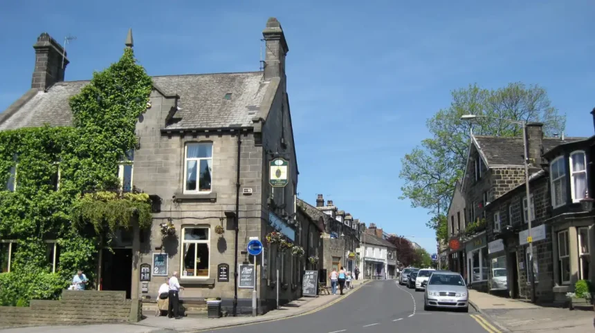
The Green and Town Street form the historic heart of Horsforth. Their layout reflects the settlement’s village origins, while surviving buildings, former commercial premises and religious sites demonstrate how the area developed from a rural community into an industrial and increasingly urban settlement.
The Green was historically one of the principal focal points of Horsforth. It formed part of the settlement’s traditional village structure before later roads and suburban development changed its surroundings.
Town Street extended the historic core and became an important route through the settlement.
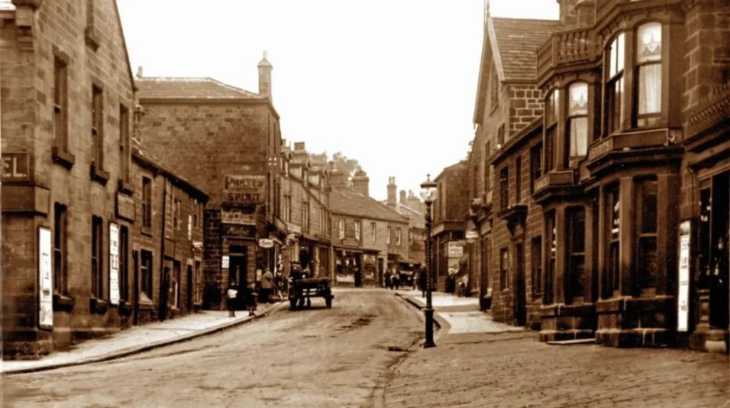
The nineteenth-century settlement remained relatively linear. Leeds City Council’s conservation appraisal describes Horsforth in 1838 as a large clothing village and records a ribbon of cottages and yards extending from The Green towards the Troy area by around 1850.
This linear structure is one of the defining features of Horsforth’s historic geography.
Instead of developing around a compact industrial centre, Horsforth expanded along roads. This pattern explains why historic buildings can appear as individual structures within a modern suburban landscape.
The Green also has an important religious connection. An early chapel stood near the area, with the site now associated with the Garden of Rest. Later religious development produced St Margaret’s Church, which became a major landmark within the historic settlement.
Visitors interested in architectural history should pay attention to building materials, roof forms, plot boundaries and the relationship between older properties and modern development.
The historic core is best understood as a landscape rather than a single attraction. Town Street, The Green, church buildings and surrounding lanes collectively reveal the evolution of the settlement.
What role did Horsforth’s churches and historic estates play?
Churches, chapels and estates provided important religious, social and economic structures in historic Horsforth. St Margaret’s Church, the former Horsforth Hall estate and the earlier chapel near The Green each represent different stages in the settlement’s development and local identity.
Horsforth’s religious history extends back to the medieval period, when the settlement was associated with the parish of Guiseley. Leeds City Council records an early chapel at The Green during the seventeenth century.
The chapel served a growing community before later religious buildings became more prominent.
St Margaret’s Church represents a significant later phase. The Stanhope family played a role in its development, with the present church replacing an earlier chapel associated with the family.
Churchyards also preserve historical information that is not always visible from streets. Gravestones, memorials and burial patterns provide evidence of local families, occupations and social structures.
Horsforth Cemetery opened in 1881 on Calverley Lane. Leeds City Council lists it as a historic municipal cemetery, although it is now full.
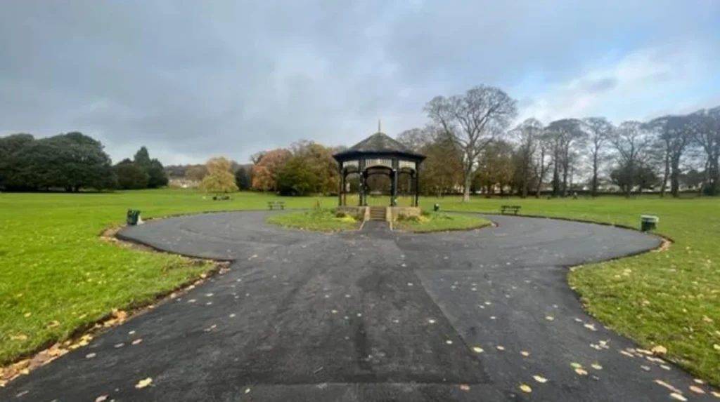
Horsforth Hall provides another important historical layer. The former estate was associated with the Stanhope family and occupied land that is now Hall Park. Although the hall itself no longer survives, the park retains the historical association with the estate.
Hall Park is therefore more than a modern green space. Its name and landscape preserve a connection with the former estate.
Leeds City Council currently identifies Horsforth Hall Park as a community park and lists St Margaret’s Church graveyard and The Green among Horsforth’s designated park and open-space sites.
How did roads and railways transform Horsforth?
Transport infrastructure changed Horsforth’s geography, economy and population by connecting the settlement more directly with Leeds and neighbouring towns. The Leeds and Bradford Railway opened through the area in 1846, while later railway development strengthened Horsforth’s northward expansion.
Road improvements preceded the railway.
A branch of the Leeds to Halifax turnpike road was constructed in 1827 to connect Horsforth with Leeds. The route became known as New Road Side.
Turnpike roads were improved routes financed through tolls. They reduced travel difficulties and strengthened commercial connections between settlements.
The railway produced an even more significant transformation.
The Leeds and Bradford Railway officially opened on 30 June 1846, with Horsforth Station included in the development recorded by Leeds City Council. The railway encouraged development towards the northern part of the settlement.
A further railway connection followed. The Leeds to Harrogate line opened three years later, with a station at Troy, associated with Horsforth. Leeds City Council’s design statement records this development as another major influence on the township.
Railways changed more than commuting.
They improved access to markets, supported movement of workers and encouraged residential expansion. Horsforth’s existing linear form became longer as properties developed towards railway stations and transport corridors.
The arrival of trams also formed part of this transition. Tram services reached the Fleece area in 1906.
Transport therefore helps explain why Horsforth developed into a substantial residential settlement rather than remaining a small rural village.
Its modern accessibility is rooted in infrastructure decisions made during the nineteenth and early twentieth centuries.
What evidence survives from Horsforth’s prehistoric and Roman past?
Archaeological evidence demonstrates that Horsforth has a history extending beyond its medieval records. Flint finds, prehistoric rock art and Roman coins provide physical evidence of earlier human activity, even though little prehistoric settlement survives visibly above ground today.
Written records do not provide the complete history of Horsforth.
Archaeology fills some of the gaps.
Leeds City Council’s conservation assessment records several prehistoric discoveries, including stray flint tools and prehistoric rock art. A ring-marked boulder was discovered near Low Hall in the late nineteenth century. Another Bronze Age carving is recorded near allotments west of Rose Terrace.
The evidence demonstrates that people interacted with the landscape before Horsforth appeared in written medieval records.
Roman activity is also represented.
Three Roman coins were discovered during the development of Horsforth Cemetery in 1909. The coins were dated between AD 238 and AD 260. Leeds City Council identifies these finds as evidence of Roman activity in the area.
The coins do not establish a Roman settlement at Horsforth. They provide archaeological evidence of activity and movement within the wider landscape.
This distinction is important when interpreting local history. A discovered object can demonstrate human activity without proving the presence of a town, fort or permanent settlement.
The archaeological potential of Horsforth remains particularly important for the medieval period through to the Industrial Revolution. The conservation assessment identifies this period as likely to contain significant archaeological evidence.
Visitors should therefore treat the historic landscape as an archaeological record as well as an architectural one.
How did Horsforth develop during the twentieth century?
Twentieth-century Horsforth experienced substantial residential growth, transport expansion and suburbanisation. Its population increased from 12,080 in 1939 to approximately 22,100 in 2005, while new roads and housing progressively extended development beyond the historic village core.
The twentieth century changed Horsforth’s physical scale.
The settlement had already expanded during the nineteenth century because of industry and railways. During the twentieth century, residential development became increasingly dominant.
Leeds City Council records a parish population of 12,080 in 1939. By 2005, the population had reached approximately 22,100, representing an increase of more than 80% over the period.
Housing growth extended beyond the traditional core.
The 1938 Ordnance Survey map showed significant development away from the historic centre, including growth associated with Broadway, now part of the outer ring road. Later decades brought further infill and housing development around the settlement’s edges.
The Second World War also forms part of Horsforth’s local history.
In November 1941, Horsforth held a Warship Week fundraising campaign. Leeds City Council records that £241,000 was raised to support the purchase of HMS Aubretia, a Royal Navy corvette. The ship later played a role in the capture of German submarine U-110 and an Enigma machine.
This episode illustrates the relationship between local communities and the national wartime effort.
Despite its population and commercial growth, Horsforth retained its village status as an urban district until its formal amalgamation with the City of Leeds in 1974. A Horsforth Town Council was later established after a petition submitted in 1999.
Why is Horsforth’s conservation area important for visitors?
Horsforth’s conservation area protects a historic environment where buildings, streets, spaces and landscape features work together as evidence of earlier settlement. The designation helps preserve the character of the historic core while allowing visitors to understand Horsforth’s long development.
Conservation areas are designated because their character or appearance has special architectural or historic interest.
Leeds City Council lists Horsforth as a conservation area and separately identifies Horsforth Cragg Hill as another designated area.
For visitors, the importance of the designation is practical. It identifies parts of Horsforth where historic buildings and the relationship between buildings and streets deserve particular attention.
The conservation area includes elements of the historic settlement around Town Street and The Green. Its character reflects the gradual evolution of Horsforth rather than a single planned development.
Historic buildings can include houses, commercial properties, religious structures and former industrial premises. Their value often comes from their position within the wider streetscape.
The conservation assessment also demonstrates how historic map evidence can reveal change. Comparing nineteenth-century Ordnance Survey maps with modern development shows the expansion of housing, transport infrastructure and commercial areas.
This makes Horsforth particularly suitable for self-guided historical exploration.
A visitor does not need to enter a museum to study the area’s history. The evidence exists in street patterns, building forms, surviving green spaces, historic routes and the relationship between the village core and later suburban areas.
Explore More Area Guide
Horsforth Relaxed Afternoon: Cafés, Parks & Activities Leeds 2026
Horsforth Visitor Guide Near Leeds: Things to Do 2026
How can visitors explore Horsforth’s history today?
Visitors can explore Horsforth’s history by combining Town Street, The Green, St Margaret’s Church, Hall Park, historic roads, railway surroundings and surviving conservation-area buildings. Walking between these locations reveals the settlement’s transition from medieval township to industrial village and Leeds suburb.
A historical visit works best as a connected walk rather than a search for one landmark.
Begin around The Green and Town Street. This area provides the clearest introduction to the historic settlement pattern. Look for older buildings, plot arrangements and the relationship between the road and surrounding properties.
Continue towards St Margaret’s Church to examine the religious history of the village. The church and its surroundings connect the modern settlement with earlier chapels and prominent local families.
Hall Park provides a different perspective. The park occupies the historic setting associated with Horsforth Hall, the former Stanhope estate building. The hall itself has disappeared, but the estate connection survives through the park’s name and landscape.
Leeds City Council lists Hall Park as a community park and The Green as a local park site.
A route towards the railway area helps explain nineteenth-century expansion. Horsforth’s railway history is essential to understanding why development extended northwards and why the settlement became increasingly connected to Leeds and neighbouring towns.
Calverley Lane also provides historical context because Horsforth Cemetery, established in 1881, occupies a site connected with the later Victorian expansion of the community.
Visitors interested in industrial history should consider the wider Newlay and Aire Valley landscape. Horsforth’s manufacturing development was not concentrated entirely within the historic core. Industrial activity developed around the valley, where water and transport supported manufacturing.
The best historical reading of Horsforth therefore comes from combining architecture, landscape, transport and archaeology.
What does Horsforth’s history tell visitors about modern Leeds?
Horsforth demonstrates how modern Leeds developed through the gradual integration of villages, industrial communities, transport corridors and suburban neighbourhoods. Its history connects medieval landholding, textile production, railway expansion, twentieth-century housing growth and the 1974 incorporation into Leeds.
Horsforth is now part of the metropolitan fabric of Leeds, but its historic identity remains visible.
The settlement’s transformation followed several distinct stages. Medieval landholding connected it to Kirkstall Abbey. The Dissolution transferred major estates into private ownership. Textile production created an industrial economy. Turnpike roads and railways improved connectivity. Twentieth-century housing expanded the built-up area. The 1974 local government reorganisation formally brought Horsforth into the City of Leeds.
The modern landscape is therefore the result of accumulated changes rather than one single redevelopment.
This is particularly useful for visitors interested in Leeds history because Horsforth provides a local-scale example of wider regional processes.
The textile economy demonstrates West Yorkshire’s industrial transformation. The railway demonstrates nineteenth-century mobility and suburban expansion. The conservation area demonstrates modern heritage management. The archaeological record demonstrates that written history represents only part of the area’s past.
Horsforth’s heritage also remains relevant to current planning.
Leeds City Council continues to identify Horsforth as a conservation area and maintains planning documentation describing its historical character.
The historic environment therefore remains part of the area’s present identity.
For tourists, Horsforth offers an accessible way to understand the layers behind a modern Leeds suburb. For residents, its historic streets and parks provide context for familiar places. For business travellers and digital nomads, a short heritage walk provides a practical way to understand the local area beyond its contemporary services and transport links.
The central lesson of Horsforth’s history is clear: its modern suburban character developed from a much older landscape shaped by agriculture, religious estates, textiles, transport and community growth.
Understanding those layers makes the present-day settlement easier to interpret.
What is Horsforth famous for?
Horsforth is known for its long history, historic village centre, textile industry, railway connections, conservation areas, and links with Kirkstall Abbey. The area developed from a medieval settlement into an industrial village and later a suburban district of Leeds.