Key Points
- Leeds City Council has published new images showcasing the redesigned Dawsons Corner junction at the intersection of the A647 Stanningley Road and the A6120 Ring Road.
- The project forms part of the broader Connecting Leeds transport strategy aimed at enhancing city-wide connectivity.
- Construction commenced in May 2025, focusing on reducing congestion, improving road safety, and facilitating future urban development.
- Councillor Jonathan Pryor, deputy leader of Leeds City Council and executive member for economy, transport, and sustainable development, highlighted the transformed, enlarged junction layout for better safety and traffic flow.
- The junction manages approximately 57,000 vehicles, 1,200 pedestrians, and cyclists daily.
- Redesigned layout seeks to optimise traffic flow, enhance air quality, support housing growth, and ensure reliable access to jobs.
- Works are on schedule, with a significant phase planned from Friday, 24 April to Monday, 27 April 2026.
- Preceding closures include Bradford Road (B6157) eastbound lane from 20 April to 24 April.
- Full closures over the weekend will affect Ring Road (A6120) Farsley and Bradford Road (B6157).
- Two-way traffic will persist on Bradford Road (A647) and Stanningley Bypass.
- Access to New Pudsey train station and Owlcotes Shopping Centre will remain open, supported by diversions for vehicles and pedestrians.
Leeds (The Leeds Times) March 28, 2026 – Leeds City Council has unveiled striking new visualisations of the redesigned Dawsons Corner junction, a pivotal upgrade at the busy crossroads of the A647 Stanningley Road and the A6120 Ring Road, integral to the Connecting Leeds transport strategy. Construction kicked off in May 2025, targeting longstanding issues of congestion and safety while paving the way for future city growth. The initiative promises a safer, more efficient junction handling 57,000 vehicles, 1,200 pedestrians, and cyclists each day.
- Key Points
- What Are the New Visuals Depicting?
- Why Is This Junction So Critical?
- When Did Construction Begin and What’s the Timeline?
- What Traffic Disruptions Are Expected?
- How Does This Fit into Connecting Leeds?
- Who Will Benefit from the Redesign?
- What Happens Next for Commuters?
- Broader Implications for Leeds Transport?
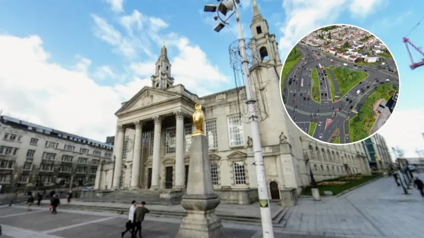
What Are the New Visuals Depicting?
The freshly released images illustrate a dramatically transformed and enlarged junction layout, prioritising safety and efficiency for all road users. As reported in the council’s official announcement, these visualisations reveal sweeping changes to the current setup, including widened approaches and refined signalling to streamline movements.
Councillor Jonathan Pryor, deputy leader of Leeds City Council and executive member for economy, transport, and sustainable development, stated:
“I am delighted to share the new visualisation of Dawsons Corner, which reveals a transformed, enlarged junction layout, making it better and safer for all road users.”
He further emphasised the multifaceted benefits, adding:
“It’s important not only to improve traffic flow and air quality, but also to support essential links to future housing growth and developments, and for people to be able to access jobs more easily with consistent travel times.”
These visuals align with the Connecting Leeds strategy, a comprehensive plan to modernise transport infrastructure across the city. By enlarging the junction, the design accommodates projected increases in traffic from nearby residential and commercial expansions, ensuring smoother integration with surrounding neighbourhoods like Farsley and Pudsey.
Why Is This Junction So Critical?
Dawsons Corner stands as a high-volume chokepoint, processing around 57,000 vehicles, 1,200 pedestrians, and numerous cyclists every day. This intense usage has long contributed to peak-hour gridlock, elevated pollution levels, and safety risks, particularly for vulnerable users such as walkers and bike riders.
The redesign directly tackles these challenges by improving traffic flow and providing superior connectivity. Enhanced pedestrian crossings, dedicated cycle lanes, and optimised vehicle phasing are among the features hinted at in the visuals, though full technical drawings remain forthcoming. The council’s focus on air quality improvements responds to Leeds’ ongoing efforts to meet national clean air targets, with better traffic dispersion expected to cut idling emissions significantly.
Supporting future development is another cornerstone. The junction’s upgrades will bolster links to emerging housing sites and employment hubs, ensuring reliable journey times even as the city expands. This forward-thinking approach underscores Leeds City Council’s commitment to sustainable growth amid rising urban pressures.
When Did Construction Begin and What’s the Timeline?
Construction at Dawsons Corner began in May 2025, marking the start of a multi-phase overhaul proceeding as planned. The project has already seen initial groundwork, including utility diversions and preliminary earthworks, with minimal disruptions to daily commuters thus far.
A major phase looms large, scheduled from Friday, 24 April to Monday, 27 April 2026. This four-day intensive period will introduce substantial traffic management measures to allow critical structural changes. Leading up to it, Bradford Road (B6157) eastbound will face lane closure from 20 April to 24 April, advising drivers to anticipate delays and seek alternatives.
Over the weekend centrepiece, the Ring Road (A6120) at Farsley and Bradford Road (B6157) will close entirely, necessitating careful planning for locals and visitors. Reassuringly, two-way traffic will continue uninterrupted on Bradford Road (A647) and the Stanningley Bypass, preserving key arterial routes.
What Traffic Disruptions Are Expected?
The upcoming closures represent the most significant interventions yet, designed to accelerate progress while managing impacts. Full shutdowns on the Ring Road (A6120) Farsley and Bradford Road (B6157) will redirect flows, with clearly signposted diversions in operation. Vehicles heading towards these areas should allow extra time, as queues could build during peak hours.
Pedestrian diversions will also be implemented, though access to essential destinations remains a priority. New Pudsey train station and Owlcotes Shopping Centre will stay reachable, with temporary paths and marshalling to guide foot traffic safely around worksites. The council urges residents to check updates via their website or app for real-time adjustments.
These measures, while inconvenient, are temporary and essential for delivering a junction that serves the community for decades. Past phases have demonstrated effective coordination, with businesses reporting manageable footfall dips and quick recovery post-works.
How Does This Fit into Connecting Leeds?
The Dawsons Corner scheme anchors within the ambitious Connecting Leeds transport strategy, which encompasses dozens of interventions citywide. This umbrella programme invests heavily in resilient infrastructure, from cycle superhighways to public realm enhancements, all geared towards a net-zero future.
By easing congestion at bottlenecks like Dawsons Corner, the strategy unlocks economic potential, supporting thousands of new homes and jobs outlined in the city’s local plan. Improved safety features, such as advanced signals and refuges, align with Vision Zero ambitions to eliminate road deaths and serious injuries.
Councillor Pryor’s comments, as cited in the release, frame the project as a linchpin for equitable access: enabling consistent travel times to workplaces and vital services. This holistic vision positions Leeds as a leader in integrated transport planning.
Who Will Benefit from the Redesign?
All road users stand to gain, but pedestrians and cyclists receive particular attention in the new layout. The enlarged design incorporates wider footpaths and segregated paths, reducing conflict points and boosting confidence for non-motorised travel.
Drivers will notice freer-flowing traffic, especially during rush hours, thanks to additional lanes and smarter phasing. Businesses near Owlcotes and Pudsey station anticipate uplift from reliable access, while residents welcome quieter local roads as through-traffic disperses more evenly.
Future housing growth, flagged by the councillor, will rely on these upgrades to prevent overwhelming the network. Developers in the pipeline praise the proactive stance, noting it mitigates risks to planned schemes.
What Happens Next for Commuters?
Motorists and public transport users should familiarise themselves with diversion maps, available on the Leeds City Council portal. Apps like Waze or Google Maps will reflect closures in real-time, aiding navigation.
Rail passengers need not worry—New Pudsey station’s approaches stay open, ensuring seamless links to Leeds centre. Shoppers at Owlcotes can proceed as usual, with any footpath tweaks clearly marked.
The council promises ongoing communication, including signage and social media blasts. As works advance, further visualisations may emerge, building excitement for the finished product.
Broader Implications for Leeds Transport?
This project exemplifies Leeds’ multi-billion-pound push to future-proof its roads. Similar schemes at other junctions, like the ongoing Armley Gyratory rethink, share DNA with Dawsons Corner: modal prioritisation, green spaces, and tech integration.
Challenges persist—budget squeezes and supply chain hiccups have tested timelines elsewhere—but Dawsons Corner’s steady pace bodes well. Success here could accelerate approvals for peer projects, amplifying city-wide gains.
Residents’ input, gathered via consultations pre-May 2025, shaped the final design, fostering buy-in. As the 24 April phase nears, community briefings will reinforce transparency.