Horsforth is a historic town in West Yorkshire within the City of Leeds. It combines an Anglo-Saxon settlement history, medieval land ownership, Georgian and Victorian buildings, historic churches, railway heritage and surviving parkland. A self-guided heritage walk provides a practical way to understand how these layers shaped the modern town.
- What makes Horsforth suitable for a heritage walk?
- Where should a Horsforth heritage walk begin?
- What can visitors see along Horsforth’s historic streets?
- Why is Horsforth Hall Park important to local heritage?
- What historic features should visitors look for in Horsforth Hall Park?
- Why is St Margaret’s Church a key Horsforth landmark?
- How does Horsforth’s railway history fit into a heritage walk?
- What role did industry play in Horsforth’s historic development?
- How long should a self-guided Horsforth heritage walk take?
- What is the best way to explore Horsforth’s heritage responsibly?
- Why does Horsforth’s heritage remain relevant today?
The walk is particularly suitable for visitors who want to explore Horsforth without relying on a formal guided tour. Its heritage is distributed across streets, buildings, green spaces and landmarks rather than concentrated at one attraction. The historic core around The Green and Town Street provides the clearest starting point, while Horsforth Hall Park, St Margaret’s Church and the railway area add important historical context.
Leeds City Council identifies several distinct character areas within Horsforth, including Town Street, Low Lane and Troy, Broadgate, Cragg Hill and Woodside, Newlay and New Road Side, Hall Lane, Brownberrie Lane and Low Hall. Town Street contains a designated conservation area, demonstrating the importance of its historic built environment.
What makes Horsforth suitable for a heritage walk?
Horsforth is suitable for a heritage walk because its streets preserve evidence from medieval settlement, historic estates, religious buildings, transport development and Victorian expansion. The heritage landscape includes The Green, Town Street, St Margaret’s Church, Horsforth Hall Park and railway-related landmarks.
Horsforth has a long documented history. The settlement appears in the Domesday Book of 1086 under forms including Horseford, Horseforde and Hoseforde. Leeds City Council records Anglo-Saxon origins and identifies Horsforth as an established settlement before the Norman Conquest.
The name is generally associated with an Old English reference to horses and a ford. The ford is linked with a historic crossing of the River Aire, probably around Newlay. This geographical connection helps explain the settlement’s relationship with movement, trade and the surrounding river valley.
Horsforth later became closely connected with Kirkstall Abbey. The Cistercian monastery was founded in 1152 on the River Aire and acquired extensive land in Horsforth. Following the Dissolution of the Monasteries in the sixteenth century, former monastic estates were sold to private owners, including the Stanhope family.
This sequence gives a heritage walk a clear chronological structure. Visitors can begin with the ancient settlement, examine surviving historic streets and buildings, then move towards the estates, churches and transport infrastructure that shaped Horsforth from the seventeenth century onwards.

Where should a Horsforth heritage walk begin?
The Green is a strong starting point because it sits within the historic village area and places visitors close to Horsforth Village Museum, Town Street, historic buildings and local streets. The location provides immediate access to several important elements of Horsforth’s heritage.
The Green remains one of the clearest places to establish Horsforth’s historic identity. Horsforth Village Museum is located at 5 The Green in the former council chambers. The museum opened in 1988 and is run by volunteers with the purpose of preserving and presenting local history.
The museum provides useful context before or after a walking route. Its collections cover different aspects of life in and around Horsforth, helping visitors connect individual buildings and streets with wider social history.
The Green is also important because Leeds City Council recognises it as a local green space. The Horsforth Neighbourhood Plan separately identifies the Peace Garden on The Green as a protected local green space.
From The Green, the walk can continue towards Town Street. This route allows visitors to move from the historic village centre into one of the area’s most important architectural character areas.
The route should be treated as a self-guided heritage circuit rather than a single officially prescribed trail. Visitors can adjust the length according to available time while retaining the main historic landmarks.
What can visitors see along Horsforth’s historic streets?
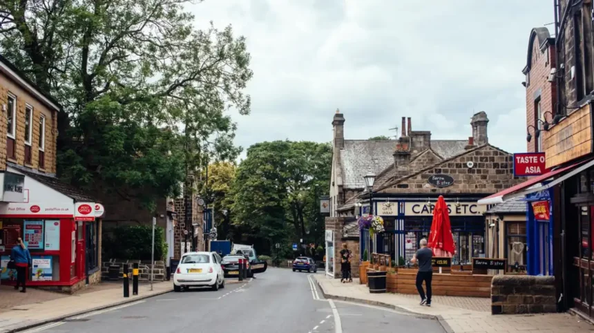
Horsforth’s historic streets contain stone buildings, older property plots, traditional terraces and surviving elements of the former village structure. Town Street is especially significant because its conservation area protects the character of a historic street environment within modern Leeds.
Town Street is central to understanding Horsforth’s physical development. Leeds City Council identifies the Town Street area as a distinct character area and confirms that part of it forms a conservation area. A conservation area is a designated place where the character and appearance of an area are considered to have special architectural or historic interest.
The historic street pattern is an important part of the experience. A heritage walk should therefore focus not only on individual listed buildings but also on the relationship between buildings, road alignment, boundaries, open spaces and older plots.
Several parts of Horsforth retain buildings associated with eighteenth- and nineteenth-century development. Leeds City Council’s conservation documentation identifies Grade II listed eighteenth- and nineteenth-century houses within parts of the Horsforth conservation landscape.
The stone construction visible across the historic core reflects the local architectural tradition of West Yorkshire. Traditional stone walls, slate roofs, older door openings and small-scale building plots provide physical evidence of earlier settlement patterns.
Visitors should observe how historic buildings sit alongside modern shops, cafés, houses and services. This contrast demonstrates how Horsforth developed from a village into an urban community while retaining significant parts of its earlier character.
As you explore the modern streets, you are crossing land shaped by centuries of settlement and ownership. Read about the full [Insert Anchor Text for History Article Here] to understand its origins.
Why is Horsforth Hall Park important to local heritage?
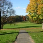
Horsforth Hall Park is historically important because it occupies the former grounds of Horsforth Hall, an estate house built between 1699 and 1707. The park retains historic structures, including the listed stable block, and preserves the landscape framework of the former estate.
Horsforth Hall was associated with the Stanhope family, one of the principal landowning families in the area’s post-Dissolution history. John Stanhope began building the house in 1699, and the completed building dates from the early eighteenth century. Leeds Libraries records that the house was completed by 1707.
The hall itself no longer survives. It was demolished during the 1950s after structural problems affected the building. The surrounding landscape, however, remains an important historical resource.
William and Mrs Mathieson purchased the hall and park and donated them to the people of Horsforth in May 1932. The grounds subsequently developed as a public recreational space.
Leeds City Council’s heritage assessment states that the park’s present grounds reflect those associated with the demolished Horsforth Hall. The former formal gardens were still identifiable on the 1847 Ordnance Survey map. The site therefore has archaeological significance as well as landscape value.
The surviving stable block is particularly important. Historic England lists the Stable Block to Former Horsforth Hall as Grade II. It contains a carved date stone marked 1707 and retains historic sandstone construction and architectural features.
A walk through Hall Park should therefore include the stable block and the general arrangement of the grounds. The absence of the hall itself is part of the site’s history. The landscape records an estate that changed from private ownership to public use.
What historic features should visitors look for in Horsforth Hall Park?
Visitors should look for the Grade II listed former Horsforth Hall stable block, historic parkland, the former hall site, the war memorial and other surviving landscape features. Together, these elements demonstrate how a private eighteenth-century estate became a public recreational landscape.
The stable block is the most substantial surviving building directly associated with Horsforth Hall. Historic England describes it as a later eighteenth-century structure incorporating a 1707 datestone. It is built from coursed squared sandstone with a stone slate roof.
The building originally formed part of the service infrastructure of the estate. Its function was different from that of the main hall because stables and associated spaces supported transport, horses and estate operations.
The former hall site also deserves attention. The building’s demolition removed the principal architectural feature of the estate, but its location remains incorporated within the park landscape. Leeds City Council identifies archaeological implications associated with both the demolished hall and its formal gardens.
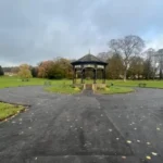
The park contains other historic structures and features. Leeds City Council identifies the bandstand, listed stables and listed war memorial as features contributing to the historic significance of the area.
The park also has modern recreational functions. It is classified by Leeds City Council as a community park, showing how heritage land continues to serve residents and visitors rather than existing solely as a preserved historic site.
For a heritage walk, the park provides an important transition between architecture and landscape. The historic significance is visible not only through buildings but through the survival of the estate’s spatial structure.
Why is St Margaret’s Church a key Horsforth landmark?
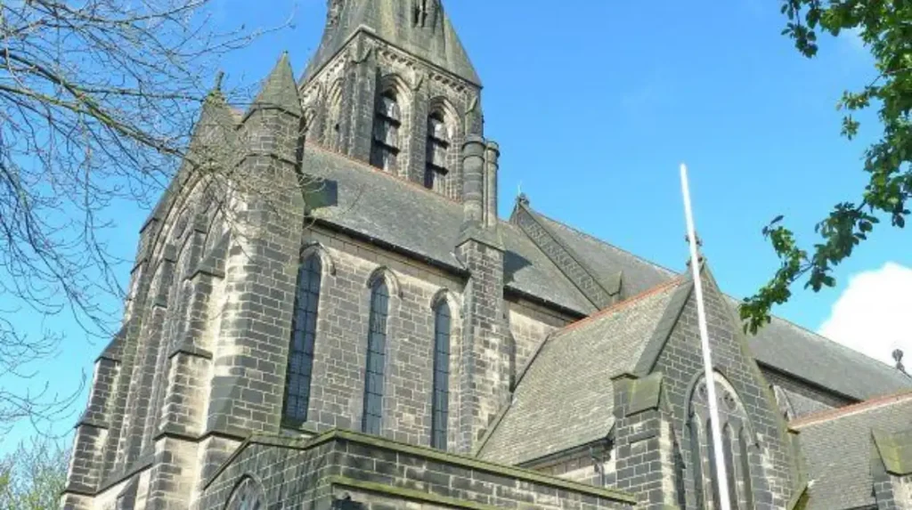
St Margaret’s Church is a major Horsforth heritage landmark because of its prominent position, historic setting and preserved interior. Its churchyard, adjoining buildings and architectural fabric form an important historic group within the Horsforth landscape.
St Margaret’s Church stands on Church Lane and occupies a prominent position on the edge of the Hunger Hills. Archaeological and architectural research describes the building as an important historic church with a well-preserved interior.
The church is particularly valuable because heritage significance extends beyond the external walls. Research records surviving pews, pulpit, choir stalls and font within the interior. The overall internal arrangement remains sufficiently intact to communicate the building’s original architectural design.
The surrounding churchyard is also recognised within Leeds City Council’s parks and countryside records. St Margaret’s Church graveyard is included in the council’s schedule of cemetery sites.
The church should be approached as part of a wider historic group. The Horsforth Neighbourhood Plan identifies St Margaret’s Parish Centre and the adjoining church and Old Vicarage as a coherent group with architectural, social and communal value.
Visitors should check current access arrangements before entering the church. A self-guided heritage walk should respect worship, funerals, private areas and any restrictions placed on photography or access.
The church provides a useful point for understanding the role of religion in the development of the settlement. It also demonstrates how historic buildings continue to function as active community spaces rather than simply surviving as monuments.
How does Horsforth’s railway history fit into a heritage walk?
Horsforth’s railway history reflects the transformation of the settlement during the nineteenth century. Horsforth railway station opened in 1849 on the Leeds to Harrogate route, while earlier railway stations around Newlay connected the area with wider regional transport networks.
The railway reached Horsforth in 1849 when the station opened on the Leeds to Harrogate line. Historic England records that the station master’s house was an earlier eighteenth-century farmhouse with an attached barn and cottage, later enlarged in the nineteenth century.
The station changed substantially during the twentieth century. Its original station buildings were demolished in 1969 as part of wider railway rationalisation in West Yorkshire. New waiting rooms and a ticket office were subsequently constructed during redevelopment in 2002 and 2003.
The station’s history illustrates the changing relationship between Horsforth and Leeds. Railway transport increased access to employment, education, commerce and neighbouring towns. The modern station continues to provide a connection between Horsforth and destinations including Leeds and Harrogate.
Railway heritage also extends towards Newlay. Newlay station opened in 1846 on the Leeds and Bradford Railway. It was renamed Newlay and Horsforth in 1889 before reverting to Newlay in 1961. The station closed on 22 March 1965.
The former Newlay and Horsforth station therefore demonstrates that Horsforth’s railway history involved more than its current station. The wider network connected the settlement with industrial and commercial centres throughout West Yorkshire.
A walking route that includes railway-related locations gives visitors a clear picture of how transport infrastructure changed the scale and economic geography of Horsforth.
What role did industry play in Horsforth’s historic development?
Industry contributed to Horsforth’s development during the eighteenth and nineteenth centuries, alongside agriculture, estates and transport. Historic evidence identifies industrial activity around areas such as Woodside and records links with glassmaking, corn milling and the wider Aire valley economy.
Horsforth did not develop solely as a residential settlement. Leeds City Council’s conservation research records industrial development during the eighteenth and nineteenth centuries. One possible early eighteenth-century glassworks was associated with Woodside, while other industrial evidence relates to corn milling.
The settlement’s location helped shape these activities. Its proximity to the River Aire and surrounding transport routes connected Horsforth with neighbouring settlements and wider markets.
The historic ford associated with the settlement’s name is another part of this geographical context. Although the original crossing no longer functions as a modern transport route, the historical relationship between Horsforth and the river landscape remains important.
The eighteenth and nineteenth centuries brought further changes in population, housing and economic activity. Leeds City Council’s conservation assessment records a population of 2,018 in Horsforth in October 1795. The same assessment records 215 chimneys in the 1672 Hearth Tax assessment, providing evidence of the scale of earlier settlement.
These figures help establish that Horsforth had a substantial community before its modern suburban expansion. They also demonstrate why surviving streets and buildings are valuable historical evidence.
For visitors, industrial history is often visible indirectly. Building materials, street layouts, former commercial premises, transport routes and older property boundaries all contribute to understanding the economic development of the settlement.
How long should a self-guided Horsforth heritage walk take?
A practical Horsforth heritage walk takes around two to three hours when it includes The Green, Town Street, St Margaret’s Church, Horsforth Hall Park and railway heritage. Allow additional time for museum visits, photography, refreshments and closer inspection of historic buildings.
A shorter walk can focus on The Green, Town Street and nearby historic buildings. This provides a compact introduction to the old village and its conservation area.
A longer route can incorporate Horsforth Hall Park and St Margaret’s Church. These additions introduce estate history, landscape heritage, religious architecture and public-space history.
Visitors interested in transport history can extend the route towards Horsforth railway station. The distance and route should be adjusted according to weather, daylight, mobility needs and opening arrangements.
Horsforth Town Council describes the area as having three busy high streets and strong village character within the wider City of Leeds. It also identifies local heritage, the museum, Hall Park and transport connections as important features of the town.
The walk works particularly well as a flexible itinerary because several landmarks can be explored independently. Visitors do not need to complete every section to gain an understanding of Horsforth’s development.
Explore More Area Guide
Family-Friendly Places in Garforth for Weekends and Holidays (2026)
Ultimate Garforth Café Guide for Breakfast, Coffee, and Lunch 2026
What is the best way to explore Horsforth’s heritage responsibly?
The best approach is to treat Horsforth as a living community rather than an open-air museum. Stay on public routes, respect residents and worshippers, protect historic fabric, follow park regulations and confirm opening arrangements before entering museums, churches or privately managed heritage sites.
Many heritage features are integrated into ordinary residential and commercial streets. Historic buildings can therefore stand beside occupied homes and active businesses. Visitors should avoid entering private land or photographing private areas without permission.
Churches and churchyards require particular care. Worship and community activities continue alongside heritage functions. Visitors should follow posted access instructions and maintain appropriate behaviour.
Historic buildings should not be touched, climbed or altered. Stonework, memorials, boundary walls and other features form part of the physical evidence of Horsforth’s history.
Horsforth Hall Park is managed as public green space, and Leeds City Council maintains park regulations covering sites throughout the city. The council’s records specifically include Horsforth Hall Park and the St Margaret’s Church graveyard.
A responsible heritage walk also supports local institutions. The volunteer-run Horsforth Village Museum preserves local history and provides a dedicated place for visitors to learn more about the community.
The most effective approach is therefore simple: observe, photograph where permitted, use public paths, support local facilities and leave historic places unchanged for future visitors.
Why does Horsforth’s heritage remain relevant today?
Horsforth’s heritage remains relevant because historic streets, public parks, churches, transport infrastructure and community institutions continue to shape local identity. The surviving landscape connects present-day Leeds with medieval settlement, post-Dissolution land ownership, industrial growth and nineteenth-century transport expansion.
Heritage affects how people understand a place. In Horsforth, this relationship is particularly visible because modern development exists alongside historic streets and buildings.
The survival of the Town Street conservation area protects an identifiable part of the historic settlement structure. The continued use of The Green and Hall Park demonstrates that historic places can retain practical community functions.
The former Horsforth Hall grounds provide another example. The original private estate disappeared, but the landscape became public space. The stable block survived as a listed building, while the wider grounds became a community park.
Railway heritage demonstrates a different form of continuity. The original station buildings disappeared, but Horsforth railway station remains part of the regional transport network. Its history connects the modern town with the nineteenth-century expansion of rail travel.
The village museum provides a further layer of continuity. Established in 1988, it preserves local records and objects while operating from the former council chambers on The Green.
Together, these places create a heritage network rather than a collection of isolated attractions. A self-guided walk makes that network easier to understand because visitors experience the relationship between streets, buildings, parks, institutions and transport routes.
Horsforth’s heritage is therefore not limited to its oldest buildings. Its significance also lies in the survival and continued use of spaces that record how the settlement changed over nearly a thousand years.
A Horsforth heritage walk offers a structured way to examine that history on foot. Starting at The Green, continuing through Town Street, exploring St Margaret’s Church and Horsforth Hall Park, and incorporating railway history creates a coherent route through the area’s principal heritage themes.
The result is a practical introduction to Horsforth’s development from an ancient settlement recorded in Domesday to an established community within modern Leeds. Its historic streets, surviving buildings, public landscapes and transport connections provide the physical evidence needed to understand that transformation.
What is the Horsforth Heritage Walk?
The Horsforth Heritage Walk is a self-guided route exploring historic streets, buildings, churches, parks and landmarks across Horsforth in Leeds. Key stops include The Green, Town Street, Horsforth Hall Park, St Margaret’s Church and Horsforth Village Museum.