Garforth is a well-connected settlement in east Leeds with a population of more than 15,000 people, two railway stations, local employment areas, green spaces and surrounding countryside. Its main commercial streets provide the most obvious starting point, but the wider area contains quieter places that reveal different aspects of the town.
- What places in Garforth are worth discovering away from the main streets?
- Where can you find Garforth’s quieter green spaces?
- Can you discover railway history away from Garforth’s main streets?
- What can you see around Garforth Station besides the trains?
- Which historic buildings can you discover away from Garforth’s shopping streets?
- Where can you explore Garforth’s countryside edge?
- What is the Lines Way and why is it significant for Garforth?
- Which residential areas reveal another side of Garforth?
- Where can digital nomads and business travellers find quieter places to pause?
- How does Garforth’s history explain the places away from its main streets?
- How can you explore Garforth away from the busiest streets?
- Why are Garforth’s less obvious places important for future visitors?
The Garforth Neighbourhood Plan identifies green space, the rural environment, community facilities, transport, heritage and local character as important parts of the settlement. The plan was formally approved as part of Leeds’ planning framework in September 2023.
For visitors, discovering Garforth away from the busiest streets means looking beyond conventional shopping and eating destinations. Railway heritage, local green corridors, historic buildings, walking routes, residential areas and countryside edges all contribute to the character of the settlement.
What places in Garforth are worth discovering away from the main streets?
The quieter parts of Garforth include local green spaces, railway heritage, residential streets, countryside edges, community facilities and walking corridors. These places provide a different view of the settlement beyond its busiest shops, services and central commercial areas.
Garforth has a compact central area, but its identity extends well beyond the commercial core. The Garforth Neighbourhood Area includes the main settlement together with surrounding green-belt agricultural land. The official neighbourhood-plan evidence describes Garforth as approximately eight miles east of Leeds city centre and as a community of more than 15,000 residents.
This wider setting creates several types of places to explore. Examples include green corridors, local recreation areas, heritage structures, streets connected with the town’s historic expansion and routes leading towards the surrounding countryside.
The settlement’s development also explains why these locations are distributed across different parts of Garforth. Agriculture, mining, transport, housing and later suburban growth all influenced its physical form.
The Garforth Neighbourhood Plan identifies 42 Local Green Spaces, including 23 already designated through the Leeds Site Allocations Plan. This provides a substantial network of smaller spaces beyond the principal commercial streets.
Visitors looking for less obvious experiences should therefore treat Garforth as a wider neighbourhood rather than a single high street destination.
Where can you find Garforth’s quieter green spaces?
Garforth has numerous designated green spaces and green corridors away from its commercial centre. These include local recreation areas, open land, play spaces, sports grounds and countryside connections that provide opportunities for walking, informal outdoor time and observing local landscapes.
Green space is a significant part of Garforth’s planned environment. The neighbourhood plan specifically protects designated green areas and identifies opportunities for improving green infrastructure, habitat connections and access.
The planning documents identify local green spaces across the neighbourhood rather than concentrating provision in one central park. This dispersed structure gives residents and visitors different options depending on which part of Garforth they are exploring.
Examples include small amenity spaces within residential areas, larger recreational areas, children’s play areas and green corridors. These locations are particularly relevant for visitors who want a quieter activity without leaving the settlement.
Green corridors are also important because they connect built-up areas with wider landscapes. They provide routes for walking and other forms of active travel while supporting habitat connectivity.
The Garforth planning evidence also recognises the wider environmental benefits of urban vegetation. Its evidence base cites research from the University of Leeds concerning green spaces, physical activity, air quality, temperature regulation, carbon storage and flood management.
This makes Garforth’s less prominent green areas relevant not only for recreation but also for understanding how the settlement interacts with its environment.
How should visitors use Garforth’s green spaces?
Local green spaces work best as part of a walking-based exploration. Visitors can combine residential streets, recreation areas and connecting paths rather than treating each space as a separate destination.
Conditions vary between locations, so visitors should use marked paths where available and respect private land, sports facilities and residential areas.
Can you discover railway history away from Garforth’s main streets?
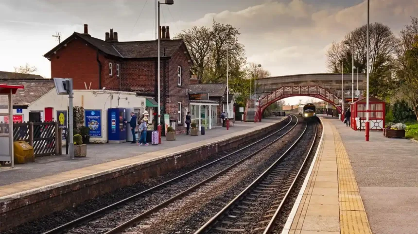
Garforth’s railway landscape provides one of its strongest examples of history outside the main shopping streets. Garforth railway station opened in 1834, and railway bridges and associated structures remain important evidence of the town’s transport development.
Railway history is central to understanding modern Garforth. The Leeds and Selby Railway opened Garforth station in 1834. Historic England records the station’s development and identifies surviving railway structures as heritage assets.
The railway transformed Garforth’s connections with neighbouring settlements and larger urban centres. It also contributed to the settlement’s later expansion.
The station area therefore offers more than a transport connection. It provides an opportunity to observe historic infrastructure within an active modern setting.
Historic England lists the footbridge at Garforth station as a Grade II listed structure. The structure dates from around 1900 and uses a standard North Eastern Railway design featuring an elliptical arch, decorative railings and ironwork.
Other railway-related heritage assets include bridges and structures associated with the historic railway network. Local heritage records identify the road bridge at Garforth station, railway bridge over Barwick Road and other railway features among Garforth’s listed heritage.
The railway environment is therefore particularly useful for visitors interested in industrial, engineering and transport history.
As you explore these modern transport surroundings, you are crossing land with a deep heritage. Read the to understand its origins and how agriculture, industry, transport and settlement shaped the town.
What can you see around Garforth Station besides the trains?
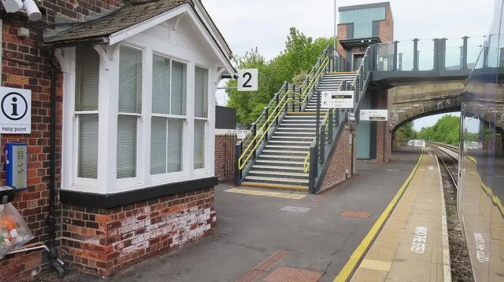
Garforth Station is an important heritage and transport location rather than simply a place to catch a train. Its historic structures, surrounding roads, railway alignment and connection with the wider settlement create a useful starting point for exploring Garforth beyond the commercial centre.
The station was established in the nineteenth century and remains part of Garforth’s modern transport network.
Its location demonstrates the relationship between transport infrastructure and urban development. The railway runs through an area that subsequently became surrounded by residential development, roads and local services.
The station also connects Garforth with destinations beyond the settlement. This makes it useful for visitors arriving by rail and then continuing on foot.
The historic railway infrastructure provides an especially clear example of how old and new functions overlap. Modern passengers use infrastructure associated with a railway system that began operating in Garforth in 1834.
Historic England’s record confirms the importance of the station’s listed footbridge and its North Eastern Railway design.
For visitors interested in architecture, transport history or industrial heritage, the station area can therefore form part of a short heritage walk.
The area is also useful as a geographical reference point. From the station, visitors can move towards residential streets, green areas and other parts of the settlement rather than remaining within the main commercial area.
Which historic buildings can you discover away from Garforth’s shopping streets?
Garforth contains historic buildings and structures that reflect its medieval origins, nineteenth-century religious development, railway expansion and agricultural past. St Mary’s Church, historic bridges, mileposts and other listed structures provide identifiable heritage points beyond the main commercial streets.
Garforth has a documented history stretching back to at least the Domesday Survey of 1086. The Garforth Neighbourhood Plan states that the Domesday record described a manor measuring about 1.5 miles by 1.5 miles and recorded a church, a priest, four villagers and one smallholder.
The figures in Domesday represent recorded households rather than a complete modern-style population count. The actual population was therefore larger than the named entries suggest.
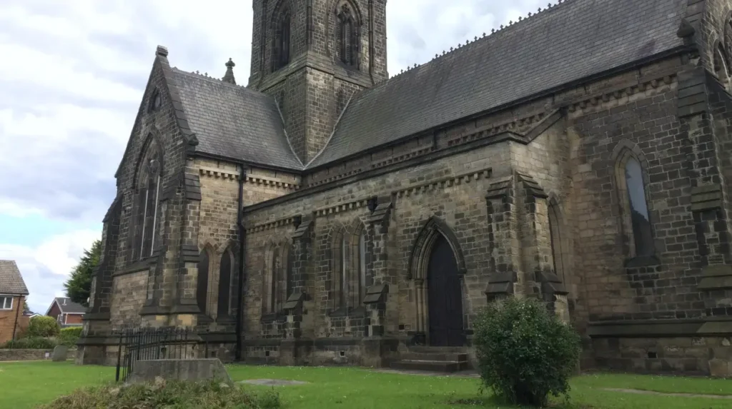
St Mary’s Church provides one of the clearest surviving connections with this earlier history. Local heritage records state that Garforth had a church recorded in Domesday and that the present church was built in 1845.
Other heritage features include historic road and railway bridges and mileposts associated with routes through Garforth. Local heritage records identify mileposts on Selby Road, Wakefield Road and Aberford Road.
These features are particularly useful because they reveal Garforth’s development through movement and infrastructure. Roads connected the settlement with neighbouring communities, while the railway later created a faster regional transport link.
Visitors interested in architecture should look beyond individual buildings and consider how these structures relate to surrounding roads, open spaces and older settlement patterns.
Where can you explore Garforth’s countryside edge?
Garforth sits within a wider landscape of agricultural land and green-belt countryside. The settlement’s outer areas provide a transition from built-up streets to open landscapes, making them useful for visitors seeking walking, landscape views and a clearer understanding of Garforth’s rural setting.
The Garforth Neighbourhood Area includes surrounding green-belt agricultural land. The official plan describes this countryside as an important part of the settlement’s setting.
The landscape also has geological significance. The Garforth Neighbourhood Plan notes that the Magnesian Limestone east of Leeds created fertile agricultural land and states that cultivation in the wider area probably dates back to the Roman period.
Agriculture therefore predates much of the modern settlement.
Evidence of earlier agricultural organisation remains visible in some locations. The neighbourhood plan notes traces of medieval field systems in the form of ridge and furrow, including grassed areas around Garforth Golf Course.
This type of landscape feature provides a direct connection between modern Garforth and earlier land use.
The countryside edge also demonstrates the contrast between Garforth’s developed areas and its agricultural surroundings. Visitors can observe how housing, roads, recreation facilities and open land meet within a relatively compact area.
When exploring these locations, visitors should distinguish public rights of way from private agricultural land. Established paths and access arrangements should always be followed.
What is the Lines Way and why is it significant for Garforth?
The Lines Way is a green corridor associated with the former railway route between Garforth and Allerton Bywater. It provides a distinctive way to experience the landscape away from central streets and connects local walking and cycling opportunities with Garforth’s industrial and railway history.
The Lines Way is one of the most relevant places for visitors seeking an experience away from Garforth’s central streets.
It follows a former railway alignment and connects the Garforth area towards Allerton Bywater. Local planning documents specifically identify the Lines Way within policies concerning green corridors and green infrastructure.
Its importance comes from the combination of transport heritage and contemporary outdoor use. A former railway corridor has become part of a green route through the landscape.
The route also demonstrates how former infrastructure can acquire a new community function. Instead of serving railway traffic, the corridor supports active travel and outdoor recreation.
Its connection towards Allerton Bywater extends the potential exploration area beyond Garforth itself. Visitors can therefore use the route as part of a longer walk or cycling journey.
The surrounding landscape changes along the route. Built-up sections give way to more open environments, creating a different experience from Garforth’s central streets.
The Lines Way is particularly relevant for visitors interested in industrial heritage, railway history, walking and cycling because these subjects intersect in one location.
Which residential areas reveal another side of Garforth?
Garforth’s residential areas reveal how the settlement expanded from an older village into a larger modern community. Streets away from Main Street contain housing from different development periods and demonstrate the relationship between historic settlement patterns, post-war expansion and later suburban growth.
Residential streets are often overlooked by visitors because they are not conventional tourist attractions. In Garforth, however, they provide evidence of the settlement’s expansion.
The neighbourhood-plan evidence identifies Garforth as a community with a distinctive small-town identity and describes development extending across several periods. It also records the importance of housing, infrastructure and green space in shaping the settlement.
Historic maps provide an additional way to understand this change. Garforth’s planning archive includes comparative maps showing development in 1899, 1939 and the present day.
These periods show how the settlement grew from an older village structure into a more extensive built-up area.
Visitors can therefore use residential streets as part of a broader urban-history walk. Older buildings, street layouts, later housing estates and open spaces demonstrate different phases of growth.
This approach is particularly useful for repeat visitors. Instead of focusing exclusively on commercial destinations, visitors can examine how Garforth functions as a lived-in settlement.
Residential areas should, however, be treated as neighbourhoods rather than visitor attractions. Visitors should avoid entering private property and should keep public exploration to roads, pavements and recognised public routes.
Where can digital nomads and business travellers find quieter places to pause?
Visitors working remotely should look beyond Garforth’s busiest streets towards quieter cafés, community facilities, green spaces and transport-connected areas. These locations provide different environments for short breaks, informal work and downtime while keeping visitors close to the wider town.
Garforth has local employment areas as well as strong connections with larger employment centres. The neighbourhood-plan evidence states that residents commute to places including Leeds, York and Wakefield.
This makes the settlement relevant to domestic business travellers as well as leisure visitors.
For remote workers, the practical question is not simply where to find a desk. Reliable transport, food and drink, access to shops, quiet surroundings and opportunities for breaks all affect how useful a location becomes during a working day.
Garforth’s two railway stations provide an important transport advantage. The settlement’s planning documentation identifies both stations as part of its existing infrastructure.
A visitor can therefore combine a short work session with a walk, local meal or heritage exploration without needing to travel into central Leeds for every activity.
Green spaces also provide a straightforward way to separate work time from downtime. A short walk between tasks creates a different environment from remaining inside a café or accommodation.
Visitors requiring Wi-Fi, power sockets or formal workspace should confirm current facilities directly with individual businesses before relying on them for work.
How does Garforth’s history explain the places away from its main streets?
Garforth’s less obvious places make more sense when viewed through its history of agriculture, medieval settlement, local estates, industry, railways and twentieth-century expansion. The present settlement is the result of these overlapping phases rather than a single period of development.
Garforth’s origins are linked to an agricultural landscape. The neighbourhood plan identifies a probable Roman agricultural presence and an Anglo-Saxon origin for the name Garforth. It records the name as meaning “ford by a triangular piece of land”.
The Domesday Survey provides the first detailed written description from 1086.
Later development involved important local landowners. Historical evidence from Garforth’s heritage archive identifies the Gascognes as influential Lords of the Manor whose impact extended across industry, housing, education, welfare and religion.
Industrial development then altered the scale and function of the settlement.
Railway construction in 1834 created a significant transport connection. The railway subsequently became an important component of Garforth’s physical development.
The twentieth century brought further administrative and residential change. Garforth Urban District Council was established in 1908, expanded to include Kippax and Allerton Bywater in 1939 and was incorporated into the Leeds metropolitan system in 1974.
This sequence explains why Garforth contains such varied environments.
Agricultural edges represent its rural origins. Churches and historic structures represent older settlement phases. Railway infrastructure represents nineteenth-century transport development. Residential districts demonstrate twentieth- and twenty-first-century expansion.
Exploring away from the main streets therefore provides a more complete understanding of the settlement.
Explore More Area Guide
Garforth Food & Drink Guide: Local Cafés and Restaurants
Garforth Outdoor Spots, Walks and Green Spaces | Leeds
How can you explore Garforth away from the busiest streets?
A practical exploration of Garforth combines heritage, green space, railway infrastructure, residential streets and countryside connections. Starting near a railway station and continuing through quieter routes creates a flexible visit that does not depend entirely on the central commercial area.
Begin with a clear geographical reference point such as Garforth railway station. Examine the historic railway environment before continuing into surrounding streets.
From there, incorporate nearby heritage features where public access allows. St Mary’s Church and listed railway structures provide identifiable points for understanding Garforth’s history.
Continue towards local green spaces and recognised walking connections. The neighbourhood plan’s green-space policies identify numerous protected spaces and corridors across the settlement.
For a longer outdoor experience, consider routes associated with the Lines Way. This extends the exploration beyond the conventional town-centre environment and connects Garforth with the wider landscape.
Visitors interested in landscape history should also look towards Garforth’s countryside edge. The combination of agricultural land, green belt and developed areas illustrates the physical setting of the settlement.
A heritage-focused visit can instead concentrate on churches, bridges, railway infrastructure and older buildings.
A slower visit can combine a local food or drink stop with a walk through less commercial parts of Garforth.
The important point is that Garforth’s identity is distributed across the settlement. Its main streets provide useful services, but they do not represent the complete character of the town.
Why are Garforth’s less obvious places important for future visitors?
Garforth’s quieter areas are important because planning policy increasingly recognises green infrastructure, heritage, active travel, community facilities and local character as interconnected parts of the settlement. These assets support everyday life while also creating additional opportunities for visitors and leisure activities.
Garforth’s future development is guided partly by its neighbourhood plan, which was approved in September 2023 and now forms part of Leeds’ statutory development plan.
The plan includes policies covering green space, rural environment, transport, community facilities, business and employment. This framework demonstrates that the settlement’s identity extends beyond commercial development.
Green corridors and local green spaces have particular relevance because they connect different parts of Garforth. They also support active travel and environmental objectives.
Heritage assets provide another long-term resource. Listed structures such as railway infrastructure preserve physical evidence of earlier development while remaining within the modern town.
The Garforth planning evidence also includes habitat networks, landscape character, agricultural land classification and green-infrastructure mapping.
These resources provide a factual basis for understanding the settlement as more than a collection of streets and businesses.
For future visitors, this creates a broader range of activities. Heritage walks, green-space exploration, railway observation, countryside walks and local community experiences can complement shopping and dining.
The result is a more complete visitor experience based on Garforth’s actual geography and history.
Garforth is therefore best explored as a connected settlement with several layers. The main streets provide the most visible commercial activity, while the surrounding spaces reveal the town’s transport history, rural setting, architectural heritage, community structure and continuing development.
What are some less obvious places to discover in Garforth?
Less obvious places in Garforth include local green spaces, railway heritage around Garforth Station, residential areas, historic buildings, countryside edges and the Lines Way. These areas provide alternatives to the town’s main commercial streets.