Garforth has an architectural character shaped by its agricultural origins, turnpike roads, coal-mining industry, railway expansion and post-war growth. The Leeds suburb contains a mix of listed structures, historic terraces, former inns, churches, bridges, industrial remnants and locally recognised heritage buildings. Its architecture is strongest when viewed as a connected landscape rather than as a collection of isolated landmarks.
- What makes Garforth’s architecture distinctive?
- Which historic building is the most important architectural landmark in Garforth?
- What can you see around Garforth railway station?
- Why is the Barwick Road railway bridge worth seeing?
- What architectural details can you find on Garforth’s older terraces?
- How does the Gaping Goose contribute to Garforth’s architectural character?
- Which historic street features are easy to miss in Garforth?
- How did mining influence Garforth’s buildings?
- What role did the Gascoigne family play in Garforth’s built environment?
- How can you explore Garforth architecture on foot?
- Why is Garforth’s post-war architecture important?
- What should visitors look for when photographing Garforth architecture?
- How is Garforth’s architectural heritage protected?
- What is the future of Garforth’s local architecture?
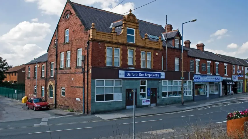
Garforth is particularly interesting for visitors who enjoy noticing architectural details during ordinary walks. Main Street, Selby Road, Aberford Road, Church Lane and the area around Garforth railway station reveal different phases of development. Red brick terraces sit alongside older stone buildings, railway infrastructure and later twentieth-century commercial architecture.
Leeds City Council’s Garforth Neighbourhood Plan identifies the town as predominantly post-war in its built form but recognises important industrial and historic heritage. The plan records eight designated heritage assets within Garforth, all Grade II listed, alongside a wider group of locally identified non-designated heritage assets. Garforth does not have a formal conservation area.
This makes Garforth especially useful for architectural exploration. Its heritage is not concentrated inside one protected historic centre. Instead, significant buildings and structures are distributed through the modern town.
What makes Garforth’s architecture distinctive?
Garforth’s architecture reflects several phases of development, including eighteenth-century turnpike growth, nineteenth-century mining and railway expansion, Victorian housing, twentieth-century industrial change and post-war suburban development. Its heritage survives through buildings, bridges, terraces, milestones and public structures.
The town’s built environment developed around transport routes and employment. Earlier settlement patterns were influenced by agriculture and local landowners. Turnpike roads increased movement through Garforth, while coal mining expanded the local economy. The Leeds and Selby Railway opened through Garforth in 1834, creating another major layer of infrastructure.
The result is a town where architectural evidence often appears beside ordinary roads. A railway bridge can sit close to twentieth-century housing. A historic public house can stand within a modern commercial street. Victorian terraces can survive behind newer retail development.
Garforth’s architectural identity also reflects its geological setting. Magnesian limestone was widely used across parts of the Leeds area, while brick became increasingly important for nineteenth-century housing and industrial construction.
The local neighbourhood plan identifies buildings and features such as Sisters Villas, Kensington Terrace, the Gaping Goose, the Miners’ Arms, St Mary’s Church, historic milestones, railway structures and other features as important components of Garforth’s heritage.
For visitors, this means architectural interest extends beyond formally listed buildings.
Which historic building is the most important architectural landmark in Garforth?
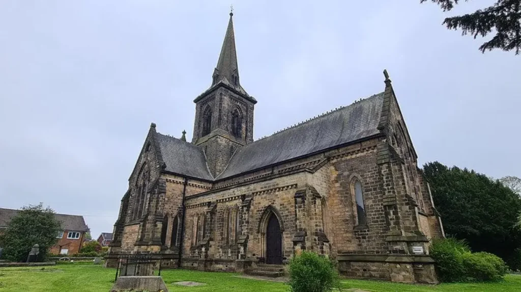
St Mary the Blessed Virgin on Church Lane is Garforth’s principal historic church landmark. Built in 1844 to designs by George Fowler Jones, it uses dressed Magnesian limestone and an Early English architectural style with a cruciform plan, crossing tower and broach spire.
St Mary’s Church provides one of the clearest examples of nineteenth-century ecclesiastical architecture in Garforth. Historic England records the church as dating from 1844 and attributes its design to George Fowler Jones, an architect associated with Gothic Revival ecclesiastical work.
The building uses dressed Magnesian limestone with a slate roof. Its plan includes a nave, north and south aisles, full-height transepts, a chancel and a crossing tower. The tower terminates in a broach spire.
The Early English style is visible through tall lancet windows, buttresses, moulded openings and the vertical emphasis of the tower. The church also has a corbel table, which is a projecting architectural band supported by carved or shaped stone blocks.
The south entrance is particularly detailed. Historic England records a shallow gabled porch with a deeply recessed outer arch, moulded orders, clustered shafts and a hoodmould with carved stops. The inner doorway has a moulded surround and large double doors with ornamental strap hinges.
The present church replaced an earlier place of worship. Local heritage research records that Garforth’s earlier church was demolished before the construction of the 1844 building. This change reflects the wider nineteenth-century expansion of the settlement.
The church is therefore significant for both architecture and urban history. It marks the period when Garforth developed a more substantial civic and religious built environment.
What can you see around Garforth railway station?
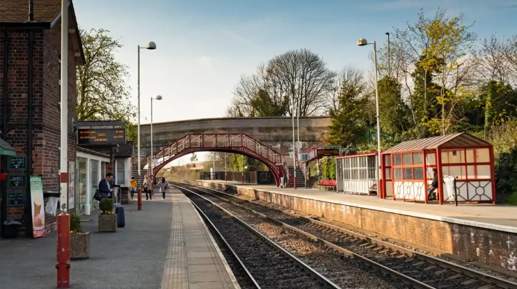
Garforth railway station contains one of the town’s most distinctive pieces of listed railway architecture: a Grade II listed cast-and-wrought-iron footbridge dating from about 1900. The nearby railway infrastructure also demonstrates the importance of nineteenth-century transport engineering.
The station’s footbridge is a strong architectural feature for visitors interested in railway design. Historic England lists it at Grade II under National Heritage List entry 1393728. It was listed on 26 March 2010.
The bridge dates from approximately 1900 and follows a standard North Eastern Railway design. Its structure uses cast and wrought iron. The main span has an elliptical arch formed in four sections, with roundels positioned in the centre of each section.
The stair railings provide another useful architectural detail. They incorporate crossed bars between iron balusters. The steps return towards the east on both sides, while the northern side rises towards the road.
The footbridge is also historically important because Garforth station itself has much earlier origins. The Leeds and Selby Railway opened the station in 1834. The railway was leased by the York and North Midland Railway in 1840 and acquired outright in 1844 before becoming part of the North Eastern Railway in 1854.
The footbridge therefore represents a later phase of railway development within an infrastructure corridor established during the early railway era.
The station area is particularly effective for architectural photography because it combines historic metalwork, railway engineering, road infrastructure, platforms and modern transport facilities in one location.
Why is the Barwick Road railway bridge worth seeing?
The Barwick Road railway bridge is a Grade II listed railway structure dating from about 1834. Built for the Leeds and Selby Railway, it uses red brick and sandstone dressings, with an elliptical arch, rusticated details, impost bands and a shaped parapet.
The bridge carries the Leeds-Selby railway over Barwick Road. Its construction belongs to the earliest phase of railway development in Garforth.
The structure is attributed to engineer George Smith and dates from approximately 1834. It is constructed from red brick with sandstone dressings. Historic records describe its elliptical-headed archway, rusticated quoins, impost bands and voussoirs around the portals. The parapet has a stone band and rounded coping with splayed ends.
A voussoir is a wedge-shaped stone or masonry block forming part of an arch. Rustication refers to masonry treated to emphasise joints or individual blocks. These details give the bridge a more formal appearance than a simple functional railway crossing.
The bridge also connects Garforth’s architecture with the engineering ambitions of the Leeds and Selby Railway. The original railway was authorised in 1830 and fully opened in December 1834. Engineer James Walker played a major role in its planning, while George Smith was involved in detailed engineering work.
The railway was originally planned with sufficient land for four tracks, although only two tracks were ultimately laid at Garforth. This explains some of the unusual scale and engineering characteristics associated with the route.
Visitors should view the bridge as transport architecture rather than simply as a road crossing. Its proportions, masonry and arch construction reveal the engineering requirements of the early railway age.
What architectural details can you find on Garforth’s older terraces?
Garforth’s Victorian terraces demonstrate how housing responded to mining employment and population growth. Kensington Terrace, built in 1854, is an important local example, while Sisters Villas dates from 1844 and connects residential architecture with the former Sisters pit.
Kensington Terrace is one of the most useful places to examine Garforth’s nineteenth-century residential architecture. The local neighbourhood plan records the terrace as dating from 1854 and identifies its historic and architectural interest.
The terrace consists of eight houses accessed through an arch near the upper part of Main Street. George Rex built the terrace. Local heritage records state that Rex began as a joiner on the Parlington Estate before establishing his own business. He built the eight homes for his four sons and four daughters.
The entrance arch is particularly important because it creates a strong relationship between the street and the residential development behind it. This type of arrangement demonstrates how nineteenth-century builders combined practical housing requirements with controlled street presentation.
Sisters Villas provides another connection between architecture and industry. The terrace dates from 1844 and stands down a lane from Barwick Road. It was built close to the former Sisters pit for the pit manager and staff.
These buildings demonstrate how Garforth’s mining economy influenced the physical form of residential streets. Housing was not separated from employment history. The location, scale and arrangement of these homes reflect the social organisation of the expanding industrial town.
Look for brickwork, rooflines, window proportions, door surrounds and the relationship between terraces and access lanes. These features help explain how nineteenth-century Garforth was built.
How does the Gaping Goose contribute to Garforth’s architectural character?
The Gaping Goose on Selby Road is one of Garforth’s best-known historic buildings. It was in use by 1822, served travellers on the former turnpike road and retains architectural details associated with later twentieth-century alterations, including Art Deco features from a 1930s refurbishment.
The Gaping Goose is important because it connects architecture with movement through Garforth. It served travellers using the former turnpike route towards Selby and was already operating by 1822. Leeds City Council’s heritage evidence identifies it as a locally important historic building.
The building has changed over time. A 1930s refurbishment introduced features that remain architecturally interesting. CAMRA’s Leeds branch records Art Deco survivals including glazed door panels, 1930s tiles and a decorative floor mosaic depicting a goose.
Art Deco is an architectural and design movement associated with geometric forms, decorative symmetry and modern materials. In the Gaping Goose, the style appears through interior fittings rather than a completely new building design.
The pub therefore demonstrates architectural layering. An older coaching establishment contains later twentieth-century design interventions.
The Gaping Goose is also significant because of its relationship with the former Garforth Old Hall. Local historical records place the old hall opposite the pub. The hall was demolished in 1958 during plans for a proposed dual carriageway. The road scheme was never completed.
That loss is important when understanding Garforth today. Some architectural history survives through buildings such as the Gaping Goose, while other structures survive only through photographs, plans and historical records.
As you explore the modern streetscape, you are crossing land with a deep heritage. Read about the full to understand its origins.
Which historic street features are easy to miss in Garforth?
Garforth contains small-scale heritage features that are easy to overlook, including historic milestones, boundary stones, decorative entrances, old plaques and architectural details on individual houses. These features provide evidence of transport, property boundaries, industry and local administration.
Milestones are among Garforth’s most important small heritage structures. The local neighbourhood plan identifies three listed milestones associated with the historic road network. Their locations include Wakefield Road, Aberford Road and the Selby Road/Ninelands Lane area.
These stones relate to the development of turnpike roads. Turnpikes were roads maintained through toll systems, with improvements supporting longer-distance travel and commercial movement.
The local heritage evidence places the surviving milestones within the development of Garforth’s turnpike routes from the eighteenth century. Their presence demonstrates that the town’s historic architecture extends beyond buildings.
Boundary stones provide another small but useful architectural feature. Garforth’s noteworthy-building inventory records boundary stones at Garforth Bridge, Garforth Cliff and Aberford Road.
Decorative residential details also deserve attention. The local heritage inventory identifies properties at Wakefield Road with notable doorways. Numbers 33 and 35 are recorded for elaborate doorway features, while number 37 has a doorway associated with the inscription “Stoneleigh 1892”.
These details are useful because they show how architectural interest operates at different scales. A visitor does not need to enter a landmark building to understand its design. Doorways, brickwork, plaques, boundary markers and roof forms provide visible evidence from public streets.
How did mining influence Garforth’s buildings?
Coal mining shaped Garforth’s housing, public buildings, street names and community identity. Industrial expansion increased employment and population, creating demand for workers’ housing, management accommodation, public houses and community facilities linked to mining communities.
Garforth’s mining heritage is closely connected to its nineteenth-century architectural development. The local neighbourhood plan identifies mining as a major influence on the town’s historic character.
Sisters Villas provides a direct architectural example because it was constructed near the former Sisters pit for the pit manager and staff. The building therefore connects residential form with industrial hierarchy.
Other buildings also preserve mining associations. The Miners’ Arms on Aberford Road is identified in the local heritage evidence as a building connected with Garforth’s mining past. It was formerly known as the Black Bull and later the Jolly Collier.
The former pit landscape itself has changed significantly. Local planning evidence records the loss of the pit winding building at the Ninelands Lane site during later housing development. The example demonstrates why industrial heritage can disappear quickly when former industrial land is redeveloped.
The coal industry also influenced local community identity. Heritage interpretation around Garforth includes references to coal tubs, mining memorials and buildings associated with workers and employers.
For architectural visitors, mining history is therefore best understood through a combination of surviving buildings, street layouts, community structures and recorded archaeological evidence.
What role did the Gascoigne family play in Garforth’s built environment?
The Gascoigne family influenced Garforth through landownership, mining and estate management. Their presence shaped local economic development and remains visible through building names, heritage references and community structures associated with the family’s long connection to the area.
The Gascoigne family became an important landowning influence in the wider Garforth area. Their estates were connected with coal extraction and the development of transport routes used to move coal.
The nearby Parlington Estate provides particularly strong evidence of this industrial landscape. Historic England records the Dark Arch at Parlington as a tunnel associated with a former wagonway used to transport coal from the Gascoigne family’s Garforth collieries towards Aberford.
The wagonway later became part of the Aberford-Garforth Railway in 1837 and remained in use until 1924. The Dark Arch is therefore an important surviving example of infrastructure created to manage both industrial transport and the appearance of an estate landscape.
Within Garforth, the Gascoigne connection is also represented through buildings and community references. The local heritage inventory identifies the Lord Gascoigne public house as a link to the family and the area’s landowning history.
The Welfare Hall is another locally recognised heritage feature associated with the Gascoignes and mining. Such buildings show how architecture can preserve relationships between landownership, industry and community life.
How can you explore Garforth architecture on foot?
A practical architectural walk should connect Garforth’s railway infrastructure, historic streets, religious architecture, former inns, terraces and smaller heritage features. A route linking Garforth station, Main Street, Church Lane, Aberford Road and Selby Road provides varied architectural evidence.
Start near Garforth railway station to examine the Grade II listed footbridge. The cast-and-wrought-iron structure provides a clear introduction to railway architecture and the town’s nineteenth-century transport history.
Continue towards Main Street and look for Kensington Terrace and its entrance arch. The terrace provides a strong example of mid-nineteenth-century housing connected with local craftsmanship and family occupation.
Move towards Church Lane to see St Mary’s Church. Focus on the limestone construction, lancet windows, buttresses, transepts, crossing tower and broach spire. These features make the building immediately recognisable as a nineteenth-century Gothic Revival church.
Continue towards Aberford Road and identify the Miners’ Arms and associated historic street features. The route provides context for understanding Garforth’s mining-era development.
The railway bridge on Barwick Road offers another architectural stop. Its red-brick construction, sandstone detailing and large arch reveal the engineering requirements of the early railway period.
Selby Road provides a different architectural experience. The Gaping Goose represents the historic coaching-road tradition, while surrounding streets contain evidence of later development.
Visitors should check access arrangements before entering churches, pubs or other privately operated buildings. Many heritage structures are best appreciated from public roads and paths.
Why is Garforth’s post-war architecture important?
Post-war Garforth forms much of the town’s present built environment. Housing estates, commercial premises, schools, community buildings and road infrastructure demonstrate how the settlement expanded after industrial-era development and adapted to modern suburban growth.
Garforth’s architectural story does not end with Victorian buildings. Leeds City Council identifies the town as predominantly post-war in its development. The neighbourhood plan specifically states that post-war development forms an important part of Garforth’s shared heritage despite often receiving less attention than older buildings.
This period changed the scale and layout of the settlement. New housing estates expanded beyond older streets, while modern roads and commercial buildings altered established movement patterns.
Post-war buildings also provide evidence of changing expectations for housing, education, transport and public services. Their design reflects different construction methods, materials and planning principles from those used during the nineteenth century.
For architectural exploration, these buildings provide useful contrasts. Older terraces generally respond closely to existing streets and plots, while later developments often use larger planned areas.
The transition between architectural periods is particularly visible around Garforth’s established roads. Historic structures survive beside twentieth-century housing and modern commercial premises.
This mixture is a defining characteristic of contemporary Garforth. Understanding it prevents the town’s architecture from being reduced to a list of old buildings.
What should visitors look for when photographing Garforth architecture?
The strongest architectural details include arches, stonework, brick bonds, rooflines, window proportions, ironwork, railway engineering, historic signage and relationships between old and new buildings. These details reveal construction periods and changing uses without requiring interior access.
St Mary’s Church provides opportunities to photograph limestone masonry, lancet windows, buttresses and the tower. The Gaping Goose provides contrasting brickwork and surviving twentieth-century decorative details.
At Garforth station, the footbridge is particularly useful for photographing industrial metalwork. Its elliptical arch, roundels and decorative railings are distinctive features recorded by Historic England.
The Barwick Road railway bridge offers a different composition based on masonry. Its elliptical arch, sandstone dressings and parapet demonstrate how early railway engineers combined structural requirements with formal architectural treatment.
Residential streets provide smaller details. Kensington Terrace’s entrance arch, Victorian brickwork and repeated house forms demonstrate nineteenth-century speculative or planned housing. Sisters Villas provides another example of housing connected with mining employment.
Milestones and boundary stones are useful subjects because their scale contrasts with larger buildings. They also provide evidence of older transport and land-management systems.
When photographing heritage buildings, remain on public land unless permission is granted. Listed status does not automatically mean that a building is open to visitors.
How is Garforth’s architectural heritage protected?
Listed buildings in Garforth receive statutory protection under national heritage legislation, while locally identified non-designated heritage assets receive planning consideration. Garforth currently has no designated conservation area, so heritage protection depends on several complementary planning and listing mechanisms.
Historic England maintains the National Heritage List for England. Listed structures are designated because of their special architectural or historic interest. Garforth contains Grade II listed structures including St Mary’s Church, railway infrastructure, bridges and milestones.
The Grade II designation is the most common listed category and identifies buildings and structures of special architectural or historic interest.
Garforth’s planning position is distinctive because it does not have a formal conservation area. Leeds City Council’s neighbourhood planning evidence states that the town has no conservation-area designation and identifies eight designated heritage assets, all Grade II.
Local planning documents also identify non-designated heritage assets. These include buildings and features judged locally important even though they do not have statutory listing.
This distinction matters for visitors. A building does not need to appear on the national list to have architectural or historical value. Kensington Terrace, Sisters Villas, the Gaping Goose and other locally identified structures demonstrate this wider definition of heritage.
Protection and development decisions continue to evolve through planning policy. Visitors should therefore treat Garforth as a living historic environment rather than a preserved museum.
What is the future of Garforth’s local architecture?
Garforth’s future architectural character depends on retaining significant historic structures while accommodating housing, transport, commercial activity and community development. Local planning documents identify heritage conservation as an important part of maintaining Garforth’s identity during future growth.
Garforth continues to experience development pressure associated with its position within the Leeds urban area. New housing, commercial activity and infrastructure alter the physical relationship between historic and modern buildings.
The Garforth Neighbourhood Plan places heritage conservation within its wider planning objectives. It identifies historic buildings and features as important to the area’s identity and records local concern about heritage assets being lost through development.
The loss of the former pit winding building and Garforth Old Hall illustrates the consequences of redevelopment and changing transport priorities. These examples also demonstrate why photographic records, historic maps, local research and planning documentation remain important.
Future architectural interest will therefore come from both preservation and adaptation. Older buildings can retain their historic appearance while supporting modern uses. New development can also contribute to the town’s architectural record.
For visitors, this creates an important reason to explore Garforth now. Its architectural landscape contains surviving evidence from several centuries, while modern development continues to shape the streets around it.
Garforth is best understood as a layered architectural environment. St Mary’s Church represents nineteenth-century ecclesiastical design. The station footbridge represents North Eastern Railway engineering. The Barwick Road bridge preserves early railway construction. Kensington Terrace and Sisters Villas reveal residential responses to industrial growth. The Gaping Goose records the coaching-road era and later Art Deco refurbishment. Milestones and boundary stones preserve evidence at a much smaller scale.
Together, these places create a practical architectural route through Garforth. They show how transport, industry, religion, housing, commerce and local government shaped the town. For tourists, residents and travellers with limited free time, Garforth offers architectural interest directly within its everyday streetscape rather than requiring a visit to a traditional historic city centre.
What are the most interesting historic buildings in Garforth?
The most interesting historic buildings in Garforth include St Mary the Blessed Virgin Church, the Gaping Goose, Kensington Terrace, Sisters Villas and the Miners’ Arms. The town also has important railway structures, milestones and boundary stones.