Horsforth is a well-connected suburb in north-west Leeds with a distinctive combination of historic streets, residential neighbourhoods, green spaces, independent businesses, community facilities and transport links. It sits between Leeds city centre and the Aireborough area, making it useful for visitors who want to explore beyond central Leeds.
- What makes Horsforth different from other Leeds neighbourhoods?
- Which part of Horsforth is best for understanding the historic centre?
- How should visitors explore Town Street and New Road Side?
- Where can visitors find the best green spaces in Horsforth?
- What is Horsforth Cragg Hill and why should visitors explore it?
- How does the Horsforth railway area fit into a neighbourhood visit?
- Which neighbourhood areas are best for families and outdoor activities?
- How can digital nomads and business travellers explore Horsforth efficiently?
- What is the best way to plan a walking route through Horsforth?
- How has Horsforth changed from a village into a Leeds suburb?
- What should visitors know before exploring Horsforth?
The neighbourhood is particularly suited to travellers who prefer walking-based exploration. Horsforth has several identifiable local areas rather than one single visitor centre. Town Street and New Road Side provide commercial activity, while Horsforth Hall Park, The Green, Cragg Hill and areas around the railway station provide different landscapes and experiences.
Understanding these local neighbourhoods helps visitors plan their time more efficiently. A short visit can focus on the historic centre and parks. A longer stay can include residential streets, green spaces, railway connections and nearby parts of the Aire Valley.
Leeds City Council identifies Horsforth Hall Park as a community park approximately six miles north-west of Leeds city centre. The council also recognises Horsforth and Horsforth Cragg Hill as conservation areas, reflecting the architectural and historic importance of parts of the neighbourhood.
What makes Horsforth different from other Leeds neighbourhoods?
Horsforth combines historic village character, suburban streets, green spaces, local shopping and railway connections within a compact part of north-west Leeds. Its identity developed through medieval settlement, textile production, transport expansion and twentieth-century suburban growth around established streets and buildings.
Horsforth has a strong local identity within the wider Leeds urban area. Its development was shaped by agriculture, textile manufacturing, transport and residential expansion.
The name Horsforth appears in several forms in the Domesday Book of 1086. Leeds City Council’s historical documentation connects the name with a possible crossing of water involving horses, traditionally associated with the River Aire at Newlay.
The settlement expanded significantly during the eighteenth and nineteenth centuries. Textile production became an important part of the local economy. Leeds City Council records that around 1796 almost half of Horsforth’s adult population was involved in cloth weaving. Later industrial activity included tanning, corn grinding, soap making, silk spinning and other textile-related processes along Oil Mill Beck.
Transport changed Horsforth’s relationship with Leeds and neighbouring communities. A branch of the Leeds-to-Halifax turnpike road was constructed in 1827 and became associated with today’s New Road Side. The railway arrived during the nineteenth century, followed by tram services in the early twentieth century.
The modern neighbourhood therefore contains several layers of development. Historic streets sit alongside twentieth-century housing and contemporary commercial premises. This mixture is one of the main reasons visitors benefit from exploring Horsforth as a collection of neighbourhood areas rather than treating it as one uniform destination.
As you explore the modern streets, you are crossing land with a deep heritage. Read about the full [Insert Anchor Text for History Article Here] to understand its origins.
Which part of Horsforth is best for understanding the historic centre?
The historic centre is concentrated around Town Street, The Green, St Margaret’s Church and surrounding streets, where older buildings and traditional settlement patterns provide the clearest introduction to Horsforth’s development before twentieth-century suburban expansion.
Town Street provides an important reference point for understanding Horsforth’s historic core. The surrounding streets contain buildings and layouts associated with the village’s earlier development.
The Green is another useful orientation point. Historic records identify an early chapel on The Green, with the site now associated with the Garden of Rest. This gives the area religious and community significance extending beyond its present-day appearance.
St Margaret’s Church and its graveyard are also recognised within Leeds City Council’s parks and byelaw records. The inclusion of the churchyard within the council’s local site information reinforces its importance as part of Horsforth’s established historic landscape.
Visitors interested in architecture should look beyond individual landmarks. The relationship between buildings, road alignment and open spaces is important. Conservation areas protect areas where historic character has sufficient architectural or environmental value to justify additional planning controls.
Leeds City Council currently lists both Horsforth and Horsforth Cragg Hill as designated conservation areas. Their presence makes the neighbourhood particularly relevant to visitors interested in historic townscape and local architectural character.
A walking route through the historic centre works best when it focuses on the relationship between streets rather than isolated attractions. Town Street, The Green and surrounding lanes provide a useful sequence for understanding how Horsforth developed from a village into a major suburban settlement.
How should visitors explore Town Street and New Road Side?
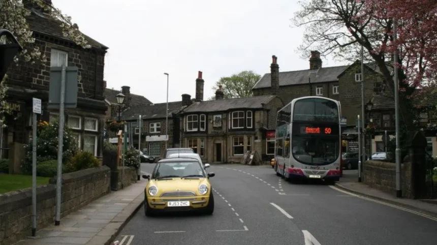
Town Street and New Road Side form Horsforth’s main commercial areas, offering access to shops, cafés, restaurants, services and everyday facilities. They also demonstrate how historic roads evolved into modern neighbourhood centres as Horsforth expanded and became increasingly connected to Leeds.
Town Street is closely associated with the historic settlement. New Road Side represents a later stage in Horsforth’s development and became increasingly important as transport infrastructure improved.
The 1827 turnpike connection between Leeds and Halifax helped strengthen movement through Horsforth. The road is now known as New Road Side and remains an important local route.
For visitors, these streets provide the practical centre of a Horsforth exploration. They are useful places to combine food, shopping and short walking sections without travelling back into Leeds city centre.
The commercial landscape also shows the difference between Horsforth and purpose-built shopping districts. Businesses are integrated into established streets and residential areas rather than concentrated entirely within a large shopping centre.
Visitors should therefore allow time to explore side streets around the main commercial corridors. Architectural details, older properties and changing building styles become easier to identify away from the busiest sections.
New Road Side is also useful for visitors arriving from other parts of Leeds by road or bus. Its position within the wider transport network makes it a practical starting point for exploring surrounding areas.
For digital nomads and business travellers, the commercial centre provides a convenient base for combining daytime work with local exploration. Cafés and other public-facing businesses provide places to take breaks between meetings, while the surrounding streets remain accessible on foot.
Where can visitors find the best green spaces in Horsforth?
Horsforth Hall Park is the area’s principal community park, while Cragg Hill Recreation Ground, King George’s Playing Fields, Stanhope Recreation Ground and other local green spaces provide additional places for walking, recreation and outdoor downtime across the neighbourhood.
Horsforth has a substantial network of parks and local green spaces. Leeds City Council’s records include Horsforth Hall Park, Cragg Hill Recreation Ground, King George’s Playing Fields and Stanhope Recreation Ground among the area’s recognised recreational spaces.
Horsforth Hall Park is the most significant destination for visitors. Leeds City Council describes it as a large community park around six miles north-west of Leeds city centre.
The park contains scenic walking routes, a cricket pitch, trim trail, Japanese garden, skate park and integrated play facilities. It also has an additional playground incorporating a climbing feature known as the Spider’s Web.
Accessibility is an important feature. Leeds City Council states that the main paths are suitable for wheelchair users and that entrances are wheelchair accessible. Two disabled parking bays are available in the main car park off Hall Lane.
The park also demonstrates the community role of Horsforth’s green infrastructure. Its facilities serve children, families, recreational users and people seeking quieter outdoor space.
Cragg Hill provides a different environment. It sits within the part of Horsforth recognised separately through the Horsforth Cragg Hill Conservation Area. This makes the area useful for visitors interested in the relationship between green space, topography and historic development.
Leeds’ wider parks strategy identifies parks as important community assets. The council states that Leeds has 70 parks and reports around 45 million adult visits to parks each year based on University of Leeds research.
This wider context explains why parks are an important part of exploring Horsforth. They are not simply recreational add-ons. They form part of the neighbourhood’s public infrastructure.
What is Horsforth Cragg Hill and why should visitors explore it?
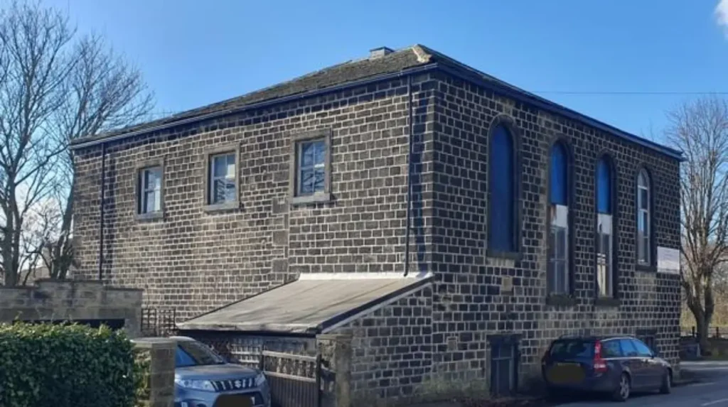
Horsforth Cragg Hill is a distinctive part of the neighbourhood associated with elevated ground, residential streets, green spaces and conservation value. It provides a different setting from the commercial centre and helps visitors understand Horsforth’s geographical and architectural variety.
Cragg Hill adds another layer to Horsforth’s neighbourhood structure. It is particularly relevant for visitors who want to move beyond Town Street and New Road Side.
Leeds City Council identifies Horsforth Cragg Hill as a conservation area. Conservation-area status recognises the importance of the area’s character and places additional consideration on development affecting its historic environment.
The area’s physical character is also important. Horsforth developed across different levels of land, and the Cragg Hill area contributes to the wider topographical identity of the suburb.
Visitors exploring this section should pay attention to changes in building form, road gradients, views and the relationship between houses and open areas. These features provide useful clues about how residential expansion adapted to the existing landscape.
Cragg Hill also connects naturally with Horsforth’s recreational spaces. Cragg Hill Recreation Ground is listed by Leeds City Council as a recognised recreation ground.
For photographers, walkers and visitors interested in urban geography, this part of Horsforth provides useful contrasts with the flatter commercial streets.
It is also an effective area for understanding suburban growth. Older settlement patterns were gradually surrounded by new housing as Horsforth’s population increased during the twentieth century.
Leeds City Council’s historical documentation records a population of 12,080 in the Horsforth parish in 1939 and approximately 22,100 by 2005. The increase reflects the substantial expansion of the settlement during the twentieth century.
How does the Horsforth railway area fit into a neighbourhood visit?
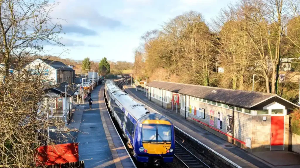
Horsforth railway station connects the neighbourhood with Leeds, Harrogate and York through the Harrogate Line, making the station area useful for visitors arriving by train and for travellers combining Horsforth with wider West Yorkshire and North Yorkshire destinations.
Horsforth railway station is located on the Harrogate Line. Northern’s current timetable information identifies the route as York to Harrogate to Leeds. The published 2026 timetable covers services between 17 May and 12 December 2026.
The station has a ticket office, ticket machine, car park, cycle facilities, toilets and step-free access to both platforms through the road bridge and ramp. Northern lists 68 car-parking spaces and 14 cycle spaces, including lockers and stands.
This makes the railway area more than a transport interchange. It can function as the starting point for a neighbourhood walk.
Visitors arriving by train can move towards local streets and green spaces rather than travelling directly into central Leeds. This provides a practical way to experience Horsforth as a destination in its own right.
The station also supports wider regional exploration. York and Harrogate are on the same rail corridor, while Leeds provides access to the wider national rail network.
For domestic business travellers, the railway connection is especially useful. A visitor can stay locally, work during the day and use rail services for meetings or leisure travel without relying entirely on a car.
The station’s facilities should still be checked before travel because opening arrangements and timetables change. Northern provides current timetable and station information for Horsforth.
Which neighbourhood areas are best for families and outdoor activities?
Families should focus on Horsforth Hall Park and nearby recreational areas because they combine playgrounds, walking routes, sports facilities and accessible paths. Different facilities serve younger children, older children and adults, making the area suitable for varied outdoor activities.
Horsforth Hall Park provides the strongest concentration of family facilities. Leeds City Council lists an integrated play facility, a separate playground for older children, a trim trail, skate park, cricket pitch and Japanese garden.
The integrated play area has particular significance. It was developed through the Horsforth Integrated Play Project, known as HIPPO, with Mencap and Leeds City Council’s Parks and Countryside service. The facility was designed to allow disabled and non-disabled children under eight to play together.
This makes Hall Park useful for families with different accessibility requirements.
The park’s paths also support visitors who prefer walking rather than structured recreation. Wheelchair-suitable paths and accessible entrances make the park easier to include in a mixed-age itinerary.
Older children have access to additional play equipment, while the skate park provides a different recreational option.
King George’s Playing Fields and other local recreation grounds expand the choice of outdoor spaces. Leeds City Council’s parks records identify these locations as recognised recreational areas within Horsforth.
Visitors should distinguish between community parks, recreation grounds and local green spaces. They do not necessarily offer identical facilities. Checking the specific location before travelling helps families choose a suitable destination.
A practical family itinerary can therefore combine the historic centre with Hall Park. This approach keeps travel distances manageable while providing a balance between heritage, food and outdoor recreation.
How can digital nomads and business travellers explore Horsforth efficiently?
Digital nomads and business travellers can combine work and leisure by using Horsforth’s commercial streets during working hours and exploring parks, heritage areas and railway connections during breaks. The neighbourhood’s compact structure supports short walking trips without requiring repeated journeys into central Leeds.
Horsforth is suitable for visitors who need to balance work with local exploration because its commercial and residential areas are closely connected.
Town Street and New Road Side provide access to food, services and everyday amenities. These areas are therefore practical for breaks between meetings or work sessions.
The railway station adds another advantage. Direct rail services place Horsforth on the Leeds-Harrogate-York corridor, while Leeds itself provides connections to wider destinations.
For a short business stay, the neighbourhood can be explored through a sequence of compact walks.
A morning route can focus on Town Street and the historic centre. A lunchtime break can include nearby cafés and local businesses. An afternoon meeting can be followed by a walk through Horsforth Hall Park.
The approach works because Horsforth has several different types of public space within the same suburban area. Commercial streets support everyday needs, while parks provide outdoor breaks and conservation areas provide architectural interest.
Digital nomads should also distinguish between cafés intended for short visits and dedicated workspaces. Wi-Fi, power sockets, seating policies and opening times vary between businesses and change over time. Current business information should therefore be checked before relying on a venue for a full working session.
The railway station itself is not designed as a coworking space. Northern lists no Wi-Fi at the station, so visitors requiring reliable internet should plan their working arrangements elsewhere.
What is the best way to plan a walking route through Horsforth?
The most efficient approach is to divide Horsforth into three connected sections: the historic centre around Town Street and The Green, the commercial area around New Road Side, and the recreational area around Hall Park and Cragg Hill. This creates a balanced local itinerary.
A structured walking route prevents visitors from overlooking the differences between Horsforth’s neighbourhood areas.
Start in the historic centre around Town Street and The Green. This section establishes the area’s earlier settlement pattern and provides access to historic buildings and religious heritage.
Continue towards New Road Side to experience the modern commercial centre. The route demonstrates how an established village adapted to changing transport and population growth.
The next stage should focus on Horsforth Hall Park. The park provides a significant change of environment, with gardens, walking paths, sports facilities, children’s play areas and a skate park.
Visitors with additional time can extend the route towards Cragg Hill and its surrounding residential landscape. The conservation designation provides an additional reason to examine the area’s built environment rather than simply passing through it.
The railway station can be used as either the arrival or departure point. Its position on the Harrogate Line makes it practical for visitors arriving from Leeds, Harrogate or York.
A longer visit can combine Horsforth with nearby communities. The railway and road network make the neighbourhood a useful base for exploring wider West Yorkshire and North Yorkshire.
Visitors should allow additional time for stops rather than measuring the experience purely by walking distance. Food, architecture, parks and local shopping each create natural pauses.
The route also works across different travel purposes. Tourists can focus on heritage and green spaces. Families can prioritise Hall Park. Business travellers can concentrate on commercial streets and transport links. Residents can use the same framework to discover less familiar parts of their own neighbourhood.
Explore More Area Guide
Horsforth Afternoon Tea: Best Places to Visit in Leeds
Horsforth Guide to a Low-Stress Local Visit | Leeds 2026
How has Horsforth changed from a village into a Leeds suburb?
Horsforth developed from a medieval settlement into an industrial community and later a large suburban area through changes in textile production, roads, railways, tram services and housing. It formally became part of the City of Leeds in 1974 after decades of urban expansion.
Horsforth’s present-day neighbourhood structure reflects centuries of change.
During the medieval period, the settlement developed around established landholding and religious connections. Cistercian monks from Kirkstall Abbey became significant landowners in the area, with Leeds City Council’s historical material stating that they eventually controlled around three quarters of Horsforth’s land.
Industrialisation changed the local economy. Wool and cloth production became particularly important during the eighteenth and nineteenth centuries. Factories developed around Oil Mill Beck, supporting activities beyond weaving.
Transport then accelerated suburban development.
The Leeds-to-Halifax turnpike connection of 1827 improved road movement. The railway followed in the nineteenth century. Leeds City Council records the opening of the Leeds-to-Bradford line in 1846, with a station at Newlay, followed by the Leeds-to-Harrogate line in 1849 with a station at Troy, now associated with Horsforth. Tram services arrived in 1906.
Twentieth-century housing expansion transformed the scale of the settlement. Leeds City Council records show Horsforth’s parish population rising from 12,080 in 1939 to around 22,100 by 2005.
Horsforth remained an urban district rather than becoming an independent town. It was formally amalgamated with the City of Leeds in 1974. Horsforth Town Council was subsequently established in 1999 following a petition.
This history explains the modern neighbourhood pattern. Historic streets survive alongside suburban housing, commercial centres, parks and major transport routes.
What should visitors know before exploring Horsforth?
Visitors should treat Horsforth as a collection of connected neighbourhood areas rather than a single attraction. The historic centre, commercial streets, railway area, Hall Park and Cragg Hill each provide different experiences, while public transport makes the wider area accessible.
The most important planning consideration is distance between different parts of the neighbourhood. Horsforth is walkable in sections, but visitors should choose a route based on their available time and interests.
History-focused visitors should prioritise Town Street, The Green, St Margaret’s Church and surrounding conservation areas.
Families should allocate substantial time to Horsforth Hall Park because its facilities extend beyond a simple walking route. The park includes play equipment, sports facilities, a trim trail, Japanese garden and skate park.
Visitors seeking local shopping and food should concentrate on Town Street and New Road Side.
Travellers using public transport should consider Horsforth railway station as an arrival point. The station provides access to the Harrogate Line and has step-free platform access, cycle facilities and parking.
Visitors interested in architecture should include Horsforth and Horsforth Cragg Hill conservation areas in their plans. Conservation status provides a useful framework for identifying areas where historic character has particular importance.
The neighbourhood is also relevant to visitors seeking quieter alternatives to Leeds city centre. Its combination of local businesses, parks and historic streets provides a different scale of urban experience.
Horsforth’s future relevance rests partly on this combination. Its transport links connect it to major regional destinations, while its parks and historic areas maintain a strong local identity.
Exploring Horsforth therefore works best as a neighbourhood experience rather than a checklist of attractions. Understanding the relationship between its historic core, commercial streets, residential districts, green spaces and transport infrastructure provides the clearest picture of how this part of Leeds developed and functions today.
What is Horsforth known for?
Horsforth is known for its historic village character, independent shops, cafés, green spaces, conservation areas and strong transport links with Leeds, Harrogate and York.