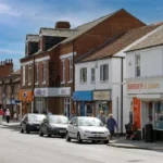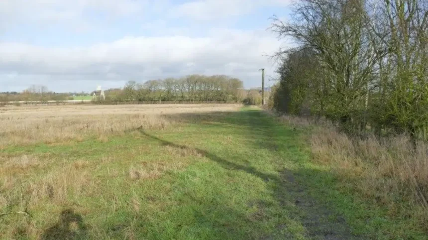
Garforth is a suburban town in the east of Leeds, West Yorkshire, with a railway station, a second station at East Garforth, local bus services, footpaths, parks and countryside connections. Its compact central area makes walking practical, while rail and buses connect visitors with Leeds and surrounding communities.
- How easy is it to explore Garforth without a car?
- Where is Garforth and what makes its location suitable for car-free travel?
- How can you travel to Garforth by train?
- How do you travel from Leeds to Garforth without driving?
- Which Garforth bus services are useful for visitors?
- What can you walk to from Garforth railway station?
- Is The Linesway suitable for a car-free day out in Garforth?
- Can you use the Leeds Country Way without a car?
- Which green spaces can you visit in Garforth without driving?
- What should visitors know about accessibility in Garforth?
- How can visitors combine walking and public transport in one day?
- Is Garforth suitable for a car-free weekend or short break?
- What are the main advantages of visiting Garforth without a car?
- What should you check before travelling to Garforth without a car?
- Why is Garforth a practical car-free destination for visitors?
For visitors without a car, Garforth offers a straightforward combination of walking, rail travel and local bus transport. The main Garforth railway station is on Station Road, close to the town centre. East Garforth station serves the eastern side of the community. Both are managed by Northern.
The town also sits beside established walking routes. Leeds City Council identifies The Linesway as a three-mile route following a disused railway between Garforth and Allerton Bywater. The Leeds Country Way also passes through Garforth, providing longer countryside walking opportunities.
Public transport gives visitors access to Leeds, Selby, Castleford and other nearby destinations. Current bus information shows services including Arriva routes 163 and 164 and First Bus services 19 and 19A serving Garforth. Timetables and routes change, so checking the operator before departure remains essential.
How easy is it to explore Garforth without a car?
Garforth is practical to explore without driving because its central streets, railway stations, bus stops, shops, green spaces and walking routes form a connected local transport network, while direct rail and bus services provide access to Leeds and nearby West Yorkshire destinations.
The easiest car-free approach is to use Garforth railway station as the arrival point and continue on foot. Station Road leads towards the town centre, where Main Street provides access to local shops, services and community facilities.
Visitors travelling from other parts of Leeds have two principal transport choices: train and bus. The railway provides a faster connection for many journeys between Garforth and Leeds, while buses provide more local stopping points.
Garforth’s geography also supports walking-based visits. The centre is surrounded by residential streets, recreation grounds, local green spaces and countryside routes. Leeds City Council lists numerous designated local green spaces around Garforth and Swillington, including BarleyHill Park, Hollinhurst Wood, The Chase, Glebelands Recreation Ground and White House Lane.
A car-free itinerary therefore does not require visitors to stay close to a single attraction. A traveller can arrive by train, walk through the centre, visit local green spaces and continue onto a public footpath before returning to the station or catching a bus.
The main consideration is distance. Garforth is walkable at town-centre scale, but countryside routes extend well beyond the central shopping streets. Comfortable footwear and advance route planning are important for longer walks.
Where is Garforth and what makes its location suitable for car-free travel?
Garforth is an established settlement in the eastern Leeds district, positioned close to major transport corridors and connected to Leeds by rail and bus. Its central railway station, local bus network and surrounding footpaths create several practical car-free travel options.
Garforth lies east of Leeds within West Yorkshire. The settlement developed around agriculture, transport routes, local industry and later residential expansion.
The Garforth Neighbourhood Plan records evidence of early cultivation in the wider area and states that the settlement’s name is probably Anglo-Saxon in origin. The Domesday Survey of 1086 provides an early detailed written description of Garforth, recording a church, priest, four villagers and one smallholder.
The modern settlement has a different physical structure from the medieval community. Housing estates, commercial areas, schools, recreation grounds and transport infrastructure now surround the historic core.
This matters for visitors because the town is not dependent on a single destination. Main Street, Station Road and surrounding roads provide access to several everyday facilities. Public transport can therefore be combined with walking rather than treated as a replacement for driving at every stage.
Garforth’s position also makes it useful as a base for wider travel. Rail services provide connections towards Leeds and York, while bus services provide additional routes towards Leeds, Selby, Castleford and surrounding settlements.
The two railway stations serve different parts of the community. Garforth station is on Station Road, while East Garforth is on Woodlands Drive.
How can you travel to Garforth by train?
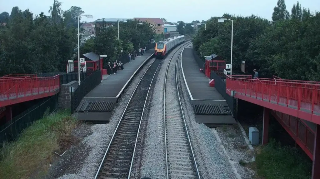
Visitors can reach Garforth by train using Garforth station on Station Road or East Garforth station on Woodlands Drive. Garforth station has lifts and step-free facilities in defined areas, while East Garforth provides step-free platform access through ramps.
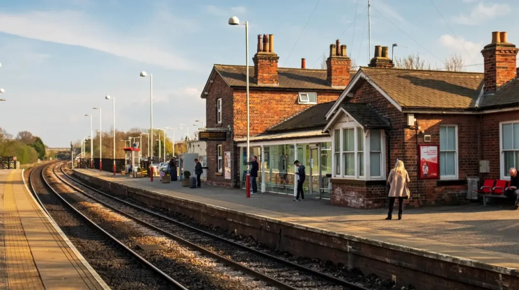
Garforth railway station is the principal rail gateway for visitors. National Rail lists the station address as Station Road, Garforth, West Yorkshire, LS25 1PY. The station is managed by Northern.
The station has several facilities relevant to car-free visitors. These include ticket machines, customer information screens, sheltered waiting areas, seating, toilets, accessible toilets and Changing Places facilities. Bicycle storage is also available.
Accessibility requires more detailed planning. National Rail classifies Garforth as category B3 for step-free access. There is step-free access to platforms from the main entrance through lifts and a footbridge, while the second entrance on Aberford Road is not suitable for wheelchair or mobility-scooter users because of its narrow footpath and curved highway.
East Garforth station is located on Woodlands Drive. National Rail classifies it as category B1, with step-free access to all platforms through long or steep ramps or streets. It has no lifts and no station car parking.
For most visitors exploring the central town, Garforth station is the more logical arrival point because of its Station Road position. East Garforth is more useful for visitors staying or visiting in the eastern part of the settlement.
Rail travel also works well for day trips. National Rail provides journey-planning information for Leeds to Garforth and identifies rail travel as an option for visiting the town.
How do you travel from Leeds to Garforth without driving?
Leeds to Garforth is served by both rail and bus, giving visitors two established public transport choices. Trains provide a direct railway connection, while buses offer additional stopping points and operate through Garforth’s local streets and surrounding neighbourhoods.
The train is the most straightforward option when the destination is close to Garforth railway station. Visitors travelling from Leeds station can use the rail network towards Garforth and then continue on foot.
The bus network provides another option. Current operator information shows Arriva services 163 and 164 serving Garforth. Arriva’s current information lists service 163 between Leeds and Castleford and service 164 between Leeds and Selby.
First Bus also lists services 19 and 19A serving Garforth. The current timetable identifies route 19 as Ireland Wood to Garforth and route 19A as Tinshill to Garforth.
This gives visitors a useful choice based on destination rather than simply transport preference. A train is particularly useful for a central Garforth arrival. A bus is useful when a stop closer to accommodation or a particular neighbourhood reduces walking distance.
Visitors should check the exact departure time before travelling. Bus timetables change by weekday, Saturday and Sunday, and operators publish temporary diversions when roadworks or incidents affect routes. First Bus currently publishes separate timetable periods and service updates, while Arriva provides live departure information and route updates.
For a return journey, checking the last available service before leaving an attraction or countryside walking route is important. Longer rural walks should not be planned around a single late bus.
Which Garforth bus services are useful for visitors?
Useful Garforth bus services include Arriva 163 and 164 and First Bus 19 and 19A. These routes connect Garforth with wider Leeds and neighbouring destinations, giving visitors additional access points beyond the railway stations and central walking routes.
Arriva service 163 provides a route between Leeds and Castleford. Current timetable information shows stops in Garforth and East Garforth, making it relevant for visitors travelling through the settlement or accessing eastern neighbourhoods.
Arriva service 164 connects Leeds and Selby. Current information shows stops around East Garforth and Garforth, including services towards Leeds and Selby.
The Arriva network also provides live departure information at Garforth Town End. Current departures include services 163 towards Leeds City Square, 164 towards Selby Bus Station, 174 towards Wetherby Bus Station and 175 towards Castleford Bus Station.
First Bus service 19 connects Garforth with Ireland Wood, while service 19A connects Garforth with Tinshill. These routes provide an alternative connection between Garforth and northern Leeds areas.
The important point for visitors is to identify the destination displayed on the bus rather than relying only on the route number. Directional destinations differ between services.
Bus stops also vary within Garforth. A stop near Main Street is useful for central destinations, while stops closer to East Garforth serve different residential areas.
Temporary changes are another consideration. First Bus currently lists service updates and planned changes for its West Yorkshire network, including Garforth-related diversions. Arriva also publishes service updates on individual route pages.
What can you walk to from Garforth railway station?
From Garforth railway station, visitors can walk towards the town centre, Main Street, local shops, community facilities, green spaces and nearby public footpaths. Longer walks connect with countryside and former railway routes, including The Linesway and sections of the Leeds Country Way.
Garforth station’s location on Station Road makes it a practical starting point for a walking visit. The central area is reached through the surrounding street network rather than requiring another motorised connection.
Main Street is particularly relevant to visitors interested in Garforth’s local character. The street forms part of the established town centre and is connected to historic buildings, community facilities and everyday retail.
The Garforth Neighbourhood Plan identifies historic structures and locations across the settlement. Examples include Sisters Villas, Kensington Terrace and the former Gaping Goose public house, demonstrating how older buildings remain part of the town’s physical history.
For visitors interested in the relationship between today’s streets and Garforth’s earlier development, the town’s heritage provides useful context. As you explore the modern site, you are crossing land with a deep heritage. Read about the full to understand its origins.
Walking beyond the centre introduces a different landscape. Leeds City Council lists The Linesway as a three-mile route along a disused railway between Garforth and Allerton Bywater. The route provides a dedicated recreational corridor and demonstrates how former transport infrastructure has become part of the walking network.
The Leeds Country Way provides another option. The official route description identifies a five-and-a-half-mile section between Barwick-in-Elmet and Garforth, with the route entering Garforth and continuing through paths towards the A63 and wider countryside.
These routes are more demanding than a town-centre walk. Visitors should allow additional time for uneven surfaces, field paths, weather conditions and route navigation.
Is The Linesway suitable for a car-free day out in Garforth?
The Linesway is one of Garforth’s most useful car-free walking corridors. Leeds City Council describes it as a three-mile route along a disused railway between Garforth and Allerton Bywater, providing a direct recreational connection through the local landscape.
The Linesway is a former railway corridor that now functions as a walking and cycling route. Its three-mile length makes it suitable for visitors looking for a longer outdoor activity without needing a car.
The route is particularly useful because it connects Garforth with the wider public rights-of-way network. A visitor can incorporate part of the route into a walking itinerary rather than committing to the full distance.
The route also demonstrates the changing function of transport infrastructure. A railway corridor that once served industrial and community transport has become recreational infrastructure.
Visitors should distinguish between an urban pavement walk and a former railway path. Conditions can differ considerably. Comfortable footwear remains appropriate, particularly when combining The Linesway with other public rights of way.
The route can also form part of a longer walk towards Allerton Bywater. Visitors should plan the return journey before setting out. A one-way walk requires a clear transport plan at the destination.
For a simple itinerary, travellers can walk from central Garforth onto the route, continue for a chosen distance, then return along the same corridor. This removes the need to coordinate a second transport mode.
Can you use the Leeds Country Way without a car?
Visitors can access sections of the Leeds Country Way from Garforth on foot, including the five-and-a-half-mile Barwick-in-Elmet to Garforth section. The route uses pavements, tracks, field paths and rural lanes before continuing towards wider countryside.
The Leeds Country Way is a 62-mile circular walking route around Leeds. Leeds City Council divides the route into sections and provides detailed descriptions of individual stages.
The Garforth section provides a direct connection between the town and surrounding countryside. The official route description states that the Barwick-in-Elmet to Garforth section is five and a half miles.
The route enters Garforth through Main Street and Church Lane before continuing towards a path near the cricket ground. It then reaches the old railway line and continues towards the A63.
This makes the route useful for visitors who want to combine public transport with countryside walking. A traveller can arrive by train, walk through the town and join a long-distance route without hiring a car.
The countryside section requires more preparation than central Garforth. Field paths, farm tracks and rural lanes form part of the route. Visitors should use an up-to-date map and check weather conditions before departure.
The route is also unsuitable for treating every section as an urban pavement. Rural rights of way have different surfaces and access conditions. Appropriate footwear and sufficient daylight are important.
Which green spaces can you visit in Garforth without driving?
Garforth has several designated green spaces that can form part of walking-based visits. Examples include BarleyHill Park, Hollinhurst Wood, Glebelands Recreation Ground, The Chase, East Garforth Recreation Ground and White House Lane.
Leeds City Council’s parks and byelaws information identifies a substantial collection of green and recreational spaces in Garforth and Swillington. The listed sites include parks, local green spaces, woodland areas and recreation grounds.
BarleyHill Park provides a local community green space. Hollinhurst Wood is identified as a woodland area. East Garforth Recreation Ground and Glebelands Recreation Ground provide recreational open space.
The Chase is another designated local green space within Garforth. White House Lane is also listed among the local green spaces.
These locations are useful for visitors because they expand the range of car-free activities beyond shopping and transport. A short walk through a green space can be combined with a town-centre visit or used as part of a longer walking route.
Access distances vary depending on the starting point. Visitors should check their chosen route before departure rather than assuming every green space is directly adjacent to the railway station.
Green-space visits also require respect for local regulations. Leeds City Council operates parks byelaws governing behaviour and use of designated sites. Visitors should follow signs, keep dogs under control where required and use paths appropriately.
What should visitors know about accessibility in Garforth?
Accessibility varies between Garforth’s transport facilities and walking routes. Garforth station has lifts and defined step-free access, while East Garforth uses ramps. Rural paths and former railway routes have different surfaces and require individual route assessment.
Garforth station has category B3 step-free access. The main entrance provides access to platforms through lifts and a new footbridge, while the Aberford Road entrance has limitations for wheelchair and mobility-scooter users.
East Garforth is category B1. National Rail states that all platforms have step-free access, although access involves long or steep ramps or streets. The station does not have lifts.
These classifications are important because step-free access does not mean that every part of the journey has the same accessibility standard.
The station environment is only one part of a journey. Pavements, road crossings, bus stops and walking paths must also be considered.
Long-distance walking routes present additional considerations. The Leeds Country Way includes dirt tracks, field paths and rural lanes. The Linesway is a former railway route and has a different surface from standard urban pavements.
Visitors requiring specific accessibility arrangements should check the latest National Rail accessibility information and consider contacting Passenger Assist before travelling. Garforth station has passenger assistance facilities.
How can visitors combine walking and public transport in one day?
The most efficient car-free itinerary combines rail or bus travel with short urban walks, followed by a planned green-space or countryside route. Visitors should select one main walking objective, confirm return transport and allow additional time for rural paths.
A practical day can begin with a train arrival at Garforth station. Visitors can then walk towards Main Street and explore the central area before continuing towards a selected green space.
A second option is to use a bus to reach a suitable stop and walk back towards the centre. This approach reduces the need to repeat the same walking section.
For longer outdoor visits, The Linesway provides a defined three-mile walking corridor. The route can be incorporated into a shorter out-and-back journey rather than completed in one direction.
A more demanding itinerary uses part of the Leeds Country Way. The official route information gives detailed directions through Garforth, including Church Lane, the cricket ground, the old railway line and paths towards the A63.
Visitors should plan the transport element before starting the walk. This means checking the next available train or bus, identifying the nearest stop or station and allowing time to reach it.
This is especially important for rural walking. A route that looks short on a map can take longer because of field gates, uneven surfaces, navigation and weather.
The best car-free itineraries therefore use public transport as the framework and walking as the main local activity.
Is Garforth suitable for a car-free weekend or short break?
Garforth works well for a short car-free visit focused on local walking, community facilities, green spaces and connections to Leeds. Its railway stations and bus routes provide transport options, while nearby countryside creates additional outdoor activities without requiring private vehicle access.
A short visit can centre on Garforth itself. The town has a defined local centre, railway access and several green spaces.
A weekend itinerary can also use Garforth as a transport-connected base for exploring nearby destinations. Rail and bus routes provide connections beyond the town, while Leeds remains accessible through established public transport services.
For visitors prioritising outdoor activities, Garforth’s position beside public rights of way is particularly relevant. The Linesway and Leeds Country Way provide established walking opportunities.
For heritage-focused visitors, the town’s historic buildings and archaeological context add another dimension. Leeds City Council’s planning documents record historic structures linked with residential development, local landowners, transport and mining heritage.
The wider Garforth area also has important archaeological significance. In 2023, Leeds City Council reported the discovery of a previously unknown 1,600-year-old cemetery near Garforth. Archaeologists identified more than 60 individuals and a lead coffin associated with a late-Roman burial.
The discovery demonstrates the depth of the area’s historical record, although the archaeological site itself should not be treated as a general visitor attraction.
A car-free weekend therefore works best when activities are grouped geographically. Visitors can combine the town centre and nearby green space on one outing, then use rail or bus travel for a separate excursion.
What are the main advantages of visiting Garforth without a car?
Travelling without a car reduces the need for parking, allows visitors to use established rail and bus connections, supports walking-based exploration and provides direct access to local footpaths, green spaces and former railway routes around Garforth.
The first advantage is transport flexibility. Visitors can choose rail for direct longer-distance travel and buses for more local stops.
The second advantage is access to walking routes. The Linesway and Leeds Country Way provide established routes that connect Garforth with the surrounding landscape.
The third advantage is simpler town-centre exploration. Visitors arriving by train do not need to locate parking before beginning their visit.
Car-free travel also creates a clear separation between transport and activity. Public transport handles the longer connection, while walking handles local movement.
This approach is especially useful for visitors staying in Leeds who want a short excursion outside the city centre. Garforth can be reached by rail or bus and explored on foot after arrival.
The transport network also supports visitors who do not want a completely walking-based day. A bus can shorten the distance between two areas, while rail can provide the main connection to and from Leeds.
Explore More Area Guide
Garforth Shopping Guide: Local Shops and Retail Areas | Garforth 2026
Family-Friendly Places in Garforth for Weekends and Holidays (2026)
What should you check before travelling to Garforth without a car?
Before travelling, visitors should check train times, bus departures, service disruptions, station accessibility, walking-route conditions and the return journey. Operator information changes regularly, so current transport information is more reliable than older journey guides.
The most important check is the public transport timetable. National Rail provides live station information and journey planning for Garforth, while bus operators publish current route schedules and service updates.
Bus services can change because of roadworks, traffic incidents and planned diversions. First Bus currently publishes planned changes for West Yorkshire, including Garforth-related service information. Arriva also provides updates on its route pages.
Visitors should also check the destination displayed on the bus. Route numbers alone do not establish direction.
For railway travel, check the station used for the journey. Garforth and East Garforth are separate stations serving different parts of the settlement.
Accessibility should be checked separately. Garforth has lifts and defined step-free facilities, while East Garforth uses ramps and has no lifts.
Finally, visitors planning countryside walks should check the walking route itself. Leeds City Council provides official descriptions for major rights-of-way routes, including The Linesway and Leeds Country Way.
Why is Garforth a practical car-free destination for visitors?
Garforth combines railway access, local bus services, a walkable central area, designated green spaces and established countryside routes. This combination gives visitors practical alternatives to driving and supports day trips based on public transport and walking.
Garforth’s transport structure makes car-free exploration realistic rather than dependent on a single service. The railway provides the principal longer-distance connection, while buses provide additional coverage.
The walking network adds another layer. Visitors can move through the centre, reach local green spaces and continue onto longer recreational paths.
The Linesway is particularly significant because it provides a three-mile former railway route between Garforth and Allerton Bywater. The Leeds Country Way adds a much longer countryside network around the city.
The town’s historic environment also rewards walking. Buildings and streets recorded in the Garforth Neighbourhood Plan demonstrate the area’s long development from an agricultural settlement into a modern urban community.
For tourists and leisure travellers, the practical formula is simple: arrive by rail or bus, explore the central area on foot, select a realistic walking route, and confirm the return connection before leaving.
For residents and business travellers, the same network supports shorter visits. A spare afternoon can include a local walk, green space or town-centre visit without hiring a car.
Garforth therefore works particularly well for visitors who value independent movement, public transport and walking. The town does not require a private vehicle for every stage of a visit. Its combination of transport and public rights of way provides a practical foundation for car-free exploration.
Can you explore Garforth without a car?
Yes, Garforth is practical to explore without a car because it has railway stations, local bus services, walkable town-centre streets, green spaces and established countryside routes including The Linesway and Leeds Country Way.