Garforth is a historic settlement in the east of Leeds, West Yorkshire, with heritage shaped by medieval settlement, parish life, turnpike roads, early railways, coal mining and Victorian expansion. Its surviving heritage includes St Mary’s Church, railway structures, milestones, historic streets and locally documented buildings.
- What is the historical background of Garforth?
- What can visitors see at St Mary’s Church in Garforth?
- Why is Church Lane important to Garforth’s local heritage?
- What railway heritage can you discover around Garforth Station?
- Which historic milestones and road features survive in Garforth?
- How did coal mining and industry shape Garforth’s heritage?
- How should visitors explore Garforth’s historic places today?
- Why does Garforth’s heritage remain important for Leeds today?
The modern town combines residential districts, transport infrastructure and commercial areas with traces of an older landscape. Understanding those traces requires looking beyond individual buildings. Roads, bridges, churchyards, railway structures and surviving street patterns all contribute to Garforth’s historical character.
The archaeological evidence also shows that Garforth developed from several historic settlements rather than from one uniformly planned village. Leeds archaeological research identifies West Garforth, Moor Garforth and Church Garforth as distinct settlements represented on mid-19th-century mapping. Church Garforth formed the most clearly identifiable historic core around Church Lane and St Mary’s Church.
For visitors, this makes Garforth particularly suitable for a heritage-focused walking visit. Several important sites stand along connected routes, allowing travellers to examine religious, transport, architectural and industrial history within a relatively compact area.
What is the historical background of Garforth?
Garforth is an ancient settlement recorded in the Domesday Survey of 1086, with medieval Church Garforth developing around its parish church. Later transport, mining and railway expansion transformed separate historic settlements into the modern town.
The Domesday Survey of 1086 provides an important documentary reference for Garforth. The settlement was established long before the Victorian period, although much of its earliest physical fabric has disappeared.
Leeds archaeological research identifies Garforth as a settlement positioned between several geological zones. Pennine Lower Coal Measures lie to the north, Pennine Middle Coal Measures to the south and dolomitised limestone occurs to the east. This geological setting influenced agriculture, building materials, quarrying and later industrial development.
The historic settlement was not a single compact village. Mid-19th-century Ordnance Survey mapping showed West Garforth, Moor Garforth and Church Garforth as separate settlements. Church Garforth centred on Church Lane and the parish church.
This distinction is important when exploring local heritage. The present-day town contains modern housing and commercial development across a much larger area than the historic core. Older heritage features therefore appear within a modern urban landscape.
The Church Lane area provides the clearest connection with medieval Garforth. Archaeological research identifies linear plots behind properties along Church Lane. These plots are consistent with historic croft arrangements associated with medieval settlement.
The historic development of Garforth is also closely connected with transport. Roads linked the settlement with neighbouring communities, while the Leeds and Selby Railway brought a major technological and economic change in the 1830s.
Coal mining subsequently became an important part of Garforth’s identity. The Gascoigne family was associated with local landownership and coal interests, while mining influenced employment, population growth and later housing development.
The result is a layered heritage landscape. Medieval religious history, Georgian and early modern road infrastructure, Victorian railway engineering, mining history and modern suburban expansion all occupy the same geographical area.
What can visitors see at St Mary’s Church in Garforth?
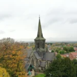
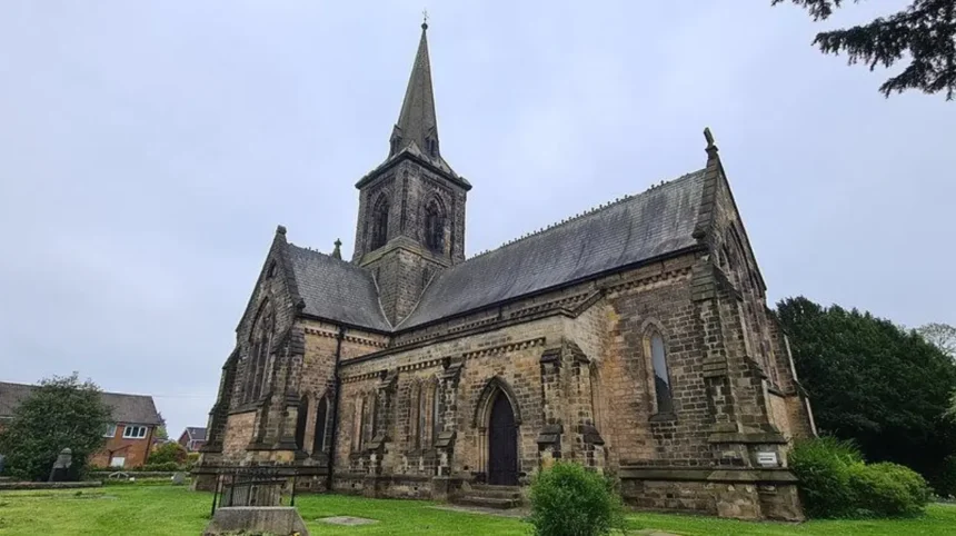
St Mary’s Church on Church Lane is Garforth’s principal surviving historic building and a Grade II listed church completed in 1844. Designed by George Fowler Jones, it uses dressed Magnesian limestone and follows an Early English Gothic Revival design.
St Mary the Blessed Virgin is the most significant surviving historic building within Garforth itself. Historic England lists the church at Grade II, recognising its special architectural and historic interest.
The present church dates from 1844. The foundation stone was laid on 22 July 1844, while local historical records state that construction was completed in 1845 and the church was consecrated on 14 November 1845.
The architect was George Fowler Jones. The building uses dressed Magnesian limestone, with slate roofing. Its plan contains a nave, aisles, transepts, chancel and crossing tower. The tower has a broach spire that creates one of Garforth’s most recognisable historic landmarks.
Historic England identifies the architectural style as Early English. Features include tall chamfered lancets, buttressing, moulded doorways and a corbel table. These details provide useful reference points for visitors interested in Victorian ecclesiastical architecture.
The church occupies an especially important historical location because an earlier church existed on the same site. Garforth’s church is recorded in the Domesday Survey, while archaeological research identifies evidence for earlier buildings on the site.
Local historical research records remnants of an Early English church dating from around 1200 within the demolished predecessor. Leeds archaeological research also identifies evidence for earlier medieval buildings and two medieval grave slabs associated with the churchyard.
Historic England’s research record adds another significant detail. A small fragment interpreted by 20th-century researchers as a possible Anglo-Saxon cross was recorded at St Mary’s. The fragment had disappeared by 1991, so it is a historical record rather than a surviving feature available for visitors today.
The church therefore represents several periods at once. Its visible architecture is predominantly Victorian, while its site has documented medieval and potentially earlier associations.
The Gascoigne family also contributed to the church. Local records state that Elizabeth and Isabella Gascoigne donated the eastern three-lancet stained-glass window in 1845. The window depicts religious scenes including the Virgin and Child, the Annunciation and the Ascension.
Visitors should treat the church as an active place of worship as well as a heritage site. Access to interior areas depends on worship, events and local arrangements.
As you explore Church Lane and the modern town, you are crossing land with a much deeper story. Read the full to understand Garforth’s origins and historical development.
Why is Church Lane important to Garforth’s local heritage?
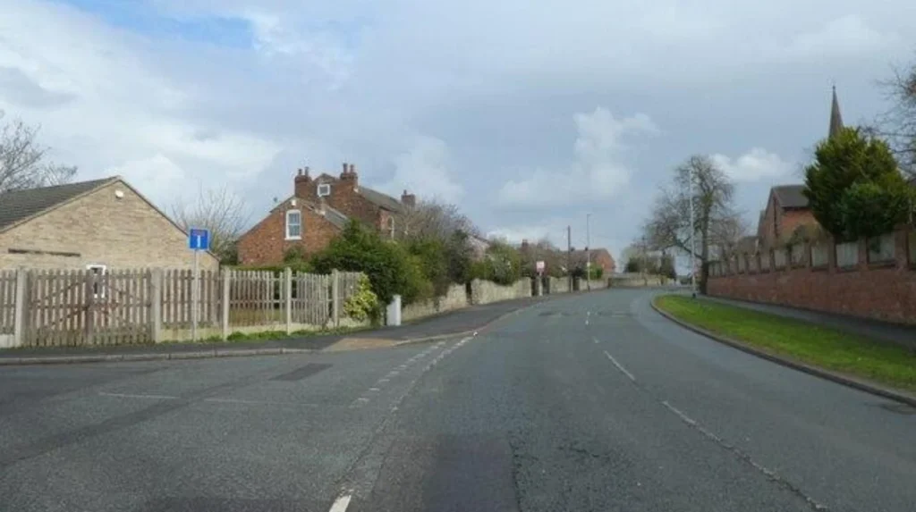
Church Lane represents the historic core of Church Garforth, where the parish church, former rectory, chapel, houses and historic land plots formed a small settlement. Its surviving layout provides evidence of how Garforth developed before modern residential expansion reshaped the town.
Church Lane is important because heritage survives through settlement patterns as well as individual buildings. The road corresponds with the historic core of Church Garforth identified in archaeological research.
In the mid-19th century, Church Garforth remained a small settlement. Archaeological analysis describes a hamlet containing a church, Methodist chapel, rectory, grange and a limited number of cottages and villas. Linear strips behind buildings along Church Lane provide evidence of earlier land organisation.
The historic environment changed considerably during the 19th and 20th centuries. Some buildings disappeared and were replaced with modern developments. The Grange, for example, was a substantial Church Lane residence associated with the local curate and later with Frederick Gray, who owned the flour mill on Aberford Road. It was demolished during the 1960s and replaced by Grangefield Court.
Rose Villa provides another example of change. The substantial house stood on Church Lane and was associated with James Rickard, who owned Sandy Quarry at Garforth Cliffe. The building was later demolished and the site redeveloped.
These losses are historically significant because they demonstrate how Garforth’s physical heritage has been altered. Heritage research therefore requires visitors to recognise both surviving structures and vanished landmarks.
The Methodist tradition is another important part of Church Lane’s history. Local records state that the first Wesleyan chapel in Garforth was built in 1806. The chapel site developed as the Methodist population expanded, with later buildings providing larger accommodation and associated educational facilities.
The Methodist buildings demonstrate how religious institutions contributed to community development during the Industrial Revolution. Religious buildings were not only places of worship. They supported education, social organisation and local community networks.
Church Lane is consequently best understood as a historic landscape rather than a collection of isolated attractions. Walking along the route allows visitors to connect the parish church, former religious buildings, historic residences and changing land uses.
What railway heritage can you discover around Garforth Station?
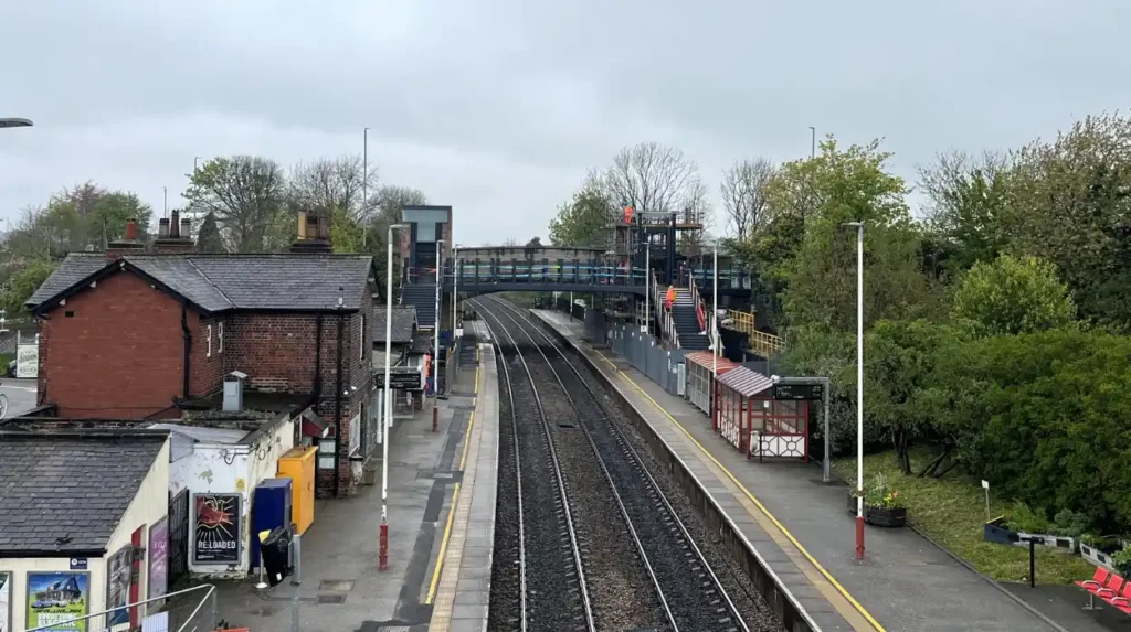
Garforth Station preserves important evidence of early railway engineering. The Leeds and Selby Railway opened Garforth Station in 1834, while the surviving Aberford Road bridge and later station footbridge demonstrate the engineering standards and expansion of Britain’s early railway network.
Railway heritage is one of Garforth’s strongest connections with the wider industrial history of Britain. The Leeds and Selby Railway was authorised in 1830 and opened fully in December 1834. Its route connected Leeds with the River Ouse at Selby through settlements including Garforth.
The railway was engineered by James Walker and associated with Walker & Burges. The original railway scheme was designed to accommodate four tracks, although only two tracks were constructed initially. This explains the unusually substantial dimensions of several surviving structures along the route.
Garforth Station opened in 1834. Historic England records that it was leased by the York and North Midland Railway in 1840 and purchased outright in 1844. It subsequently became part of the North Eastern Railway when that company was formed in 1854.
The Aberford Road Bridge is particularly important. Historic England records that the bridge was constructed for the Leeds and Selby Railway between 1830 and 1834. It was designed by Walker & Burges and constructed by Hamer & Pratt.
The bridge is listed at Grade II. Its survival provides a direct physical connection with the earliest phase of the Leeds and Selby railway system.
The station footbridge represents a later phase of railway infrastructure. Historic England identifies it as a standard North Eastern Railway design and dates its construction to around 1900. It features an elliptical arch divided into four sections, decorative railings and returning steps.
The relationship between the two bridges also reveals how railway infrastructure evolved. The original road bridge provided access over the railway before the dedicated footbridge was introduced.
Visitors interested in industrial archaeology should examine the structures from publicly accessible areas without entering restricted railway land. Railway heritage remains operational infrastructure, so safety and access restrictions take priority.
The Garforth railway structures also place the town within the national history of early railway construction. The Leeds and Selby Railway was authorised only four months before the Liverpool and Manchester Railway opened, placing its development within the formative period of Britain’s railway expansion.
Which historic milestones and road features survive in Garforth?
Garforth retains historic milestones and transport structures associated with turnpike roads and long-distance travel. Surviving milestones on Selby, Wakefield and Aberford routes provide physical evidence of historic road networks and the measurement of distances before modern transport systems.
Road heritage is less visually prominent than the parish church or railway bridges, but it provides important evidence of how people travelled through Garforth.
Local heritage research identifies milestones on Wakefield Road, Aberford Road and at the Selby Road and Ninelands Lane junction among Garforth’s oldest surviving structures. The research associates these features with the development of turnpike roads from the 18th century onwards.
A milestone served a practical purpose. It recorded distances between places and helped travellers navigate established routes. Before modern road signs, digital mapping and standardised navigation systems, milestones provided fixed geographical information.
The Garforth examples are particularly valuable because their survival connects modern roads with earlier transport infrastructure. A visitor travelling along a busy modern route can therefore encounter a small object that records a much older road system.
The Wakefield and Aberford road network also demonstrates Garforth’s strategic position between Leeds and settlements to the east and south. Turnpike improvements increased the efficiency of road travel and supported trade, movement and communication.
Historic road infrastructure also helps explain the development of roadside buildings and inns. Commercial premises developed around routes where travellers, carriers and local residents required services.
The Gaping Goose Inn is an especially notable locally documented historic building. Garforth historical research identifies it as potentially the oldest surviving building in the town, while also noting that the structure has undergone substantial alteration.
Because the building has been altered, visitors should distinguish between the age of the site or original structure and the appearance of the present building. Historic buildings frequently contain fabric from several periods.
Milestones, bridges and inns also demonstrate an important principle in heritage interpretation: historic significance does not depend entirely on monumental architecture. Small transport features can provide direct evidence of how communities functioned.
For photographers and heritage walkers, these features work best as part of a route rather than as isolated destinations. Their value comes from their relationship with historic roads, settlement patterns and nearby buildings.
How did coal mining and industry shape Garforth’s heritage?
Coal mining transformed Garforth’s economy, landscape and population during industrialisation. The Gascoigne family controlled significant local interests, while pits, quarries, brickworks, mills and associated housing connected the settlement with wider industrial development across West Yorkshire.
Industrial history is essential to understanding modern Garforth. The town developed within a wider West Yorkshire landscape where coal, transport and manufacturing influenced settlement growth.
The Gascoigne family held major land interests in the area. Historical records describe Colonel Frederick Charles Trench Gascoigne as a major landowner associated with extensive collieries during the 19th century.
Coal mining generated employment and supported associated services. Mining also influenced local identity. Garforth’s historical evidence records connections between mining, public houses, roads and community organisations.
Quarrying was another component of the local economy. James Rickard, associated with Rose Villa, owned Sandy Quarry at Garforth Cliffe. This illustrates the importance of local mineral resources beyond coal.
Brick production also contributed to Garforth’s industrial landscape. Local planning research records a clay quarry and brickworks on the site later occupied by Halliday Court. The brickworks were associated with Marshall’s and were reputed locally for producing high-quality bricks.
These industries affected the appearance of Garforth. Local research notes that although limestone occurs in the surrounding geology, red brick became the dominant building material because suitable building stone had to be transported from elsewhere.
This explains an important visual characteristic of Garforth. Visitors expecting a village dominated by local stone encounter substantial quantities of red-brick architecture instead.
Industrial development also changed the scale of the settlement. Railway access improved the movement of coal, goods and people, while mining employment increased demand for housing.
The relationship between industry and heritage remains visible through street names, surviving buildings, former industrial sites and community memories. Some industrial structures have disappeared, but their influence remains embedded in the town’s geography.
The church also contains evidence of the social relationship between mining and local community life. A memorial tablet in St Mary’s commemorated Isabella Gascoigne and was associated with miners, providing a surviving connection between the church, the Gascoigne family and the mining community.
Industrial heritage therefore extends beyond former pit sites. It includes transport, housing, religious institutions, memorials, roads and commercial buildings that developed around the industrial economy.
Explore More Area Guide
Horsforth Scenic Views, Landscapes and Outdoor Areas Leeds 2026
Garforth Half-Day Itinerary for a Quick Visit 2026
How should visitors explore Garforth’s historic places today?
The most effective heritage visit combines Church Lane, St Mary’s Church, Garforth Station, the railway bridges and surviving road features. These locations reveal Garforth’s medieval, Victorian, railway, industrial and community history through a connected local landscape.
A heritage visit to Garforth works best as a walking-based exploration of connected locations. Church Lane provides the strongest starting point for understanding the older settlement.
Begin around St Mary’s Church and examine its Early English Gothic Revival architecture, Magnesian limestone construction, tower and churchyard. Historic England’s Grade II listing provides an authoritative reference for the building’s architectural significance.
Continue along Church Lane to understand the historic settlement pattern. The modern environment contains redevelopment, but the alignment of the road and surviving buildings still provide evidence of the historic village structure.
The next stage is Garforth Station. The station and railway bridges demonstrate the transformation caused by the Leeds and Selby Railway after 1834. The Grade II listed footbridge and Aberford Road Bridge are particularly important heritage features.
Visitors should view railway structures only from safe public areas. Active railway lines are operational transport infrastructure, not archaeological sites for unrestricted access.
Road heritage can then be incorporated into a wider exploration. Historic milestones provide clues about former travel routes and the importance of long-distance road connections.
A heritage walk also benefits from comparing historical maps and modern streets. The contrast reveals how West Garforth, Moor Garforth and Church Garforth were absorbed into one expanding settlement.
For digital nomads and business travellers with limited downtime, the same approach provides a compact cultural activity without requiring a full-day excursion. The station’s location also makes Garforth accessible from the wider Leeds transport network.
Visitors interested in industrial history should research the locations of former pits, quarries, brickworks and mills before setting out. Many former industrial sites have been redeveloped, so their historical importance is often better understood through archival research than through surviving structures.
Local heritage resources provide additional information. The Story of Garforth project documents buildings, people and events along a heritage walk covering Garforth Station, Townend, Main Street, Lidgett Lane, Church Lane and St Mary’s Church.
This local documentation complements official heritage records. Historic England provides statutory information about listed structures, while archaeological research provides wider evidence about settlement development.
Together, these sources create a more accurate picture of Garforth. The town’s heritage is not limited to a single landmark. It is a network of surviving structures, historical routes, archaeological evidence and community records.
Why does Garforth’s heritage remain important for Leeds today?
Garforth’s heritage explains how a rural and medieval settlement became a major modern Leeds suburb through roads, railways, mining and housing expansion. Protecting surviving churches, bridges, milestones and historic landscapes preserves evidence of this long transformation.
Garforth’s heritage has value because it explains the development of the modern settlement. The town’s present form is the result of centuries of change rather than one period of planned growth.
The earliest evidence centres on settlement and religious activity. Church Garforth developed around its church, while West Garforth and Moor Garforth formed additional historic settlements. Their later expansion produced the larger town visible today.
The 18th-century turnpike era improved road connections. The 19th-century railway introduced faster movement of passengers and goods. Coal mining and quarrying strengthened industrial employment. Victorian churches, chapels and houses reflected population growth and changing community structures.
The survival of individual structures allows these processes to be understood in physical form.
St Mary’s Church represents Victorian religious architecture built on an older ecclesiastical site. The Aberford Road Bridge represents early railway engineering. The station footbridge represents later North Eastern Railway infrastructure. Milestones represent earlier road transport systems.
Each feature records a different stage in Garforth’s development.
Heritage protection also provides a formal mechanism for preserving nationally important structures. Listed buildings are protected under the planning system because of their special architectural or historic interest. Historic England maintains the National Heritage List for England, which records listed buildings and other designated heritage assets.
Leeds City Council also manages conservation areas across the district. Its current information records 80 conservation areas across Leeds, with appraisals and management plans available for many designated areas.
Garforth’s heritage landscape demonstrates why local history requires more than a list of famous buildings. Historic roads, railway infrastructure, churchyards, archaeological plots and vanished industrial sites all contribute evidence.
The heritage value of Garforth also extends to education and tourism. Visitors can use the town to understand the transition from medieval settlement to industrial community and modern suburban centre without travelling far from Leeds.
For residents, heritage provides a framework for understanding familiar streets. For tourists, it adds historical context to an otherwise contemporary destination. For business travellers, it offers a practical way to explore local history during limited free time.
Garforth’s future heritage value depends on maintaining this connection between surviving structures and historical evidence. Buildings such as St Mary’s Church and the railway bridges provide visible anchors. Local archives, archaeological research and community history projects provide the context that makes those structures meaningful.
The strongest interpretation therefore combines official records with local research. Historic England establishes the statutory significance of listed structures. Archaeological research explains settlement development. Local heritage projects preserve community knowledge and document buildings that have disappeared.
Garforth is consequently best understood as a layered historic landscape within Leeds. Its heritage survives in churches, railway engineering, roads, milestones, industrial references, street patterns and archaeological evidence.
Exploring these features reveals a clear sequence: an early settlement, a medieval church-centred community, improved turnpike roads, early railway development, industrial expansion and modern suburban growth.
That sequence gives Garforth a distinctive historical identity and makes its surviving heritage features valuable points of reference for understanding both the town and the wider development of Leeds.
What is Garforth famous for historically?
Garforth is historically known for its medieval settlement, St Mary’s Church, early railway heritage, coal mining, quarrying and historic road networks. The town developed significantly during the 19th century as railways and industry expanded.