Headingley’s railway history explains how a former village on the north-western edge of Leeds developed into a well-connected residential, educational and leisure district. Railway construction, suburban expansion and improvements to local transport strengthened connections between Headingley, Leeds city centre and neighbouring communities.
- What Was Headingley Like Before the Railway Arrived?
- When Did the Railway Reach Headingley?
- How Did Headingley Railway Station Change Local Travel?
- How Did the Railway Influence Headingley’s Residential Growth?
- What Role Did Burley Park Station Play in Local Transport?
- How Did Buses and Trams Complement Headingley’s Railway?
- How Did Railway Development Affect Headingley’s Economy and Education?
- How Did Railway Services Change During the Twentieth Century?
- What Is the Difference Between Headingley’s Historic Railway and Today’s Network?
- How Can Visitors Explore Headingley’s Railway History Today?
- Where Can Researchers Find Reliable Records of Headingley’s Railway History?
- Why Does Headingley’s Railway History Still Matter Today?
The arrival of rail services changed how people travelled to work, accessed education, visited sporting venues and settled outside the industrial centre of Leeds. Today, Headingley railway station and Burley Park railway station remain important parts of the local transport network, serving residents, students, commuters and visitors.
Understanding this development helps visitors explore Headingley beyond its present-day shops, pubs, university buildings and sporting attractions. The railway corridors, station locations and surrounding streets reveal how transport infrastructure influenced the district’s growth.
What Was Headingley Like Before the Railway Arrived?
Before railway expansion, Headingley was a village north-west of Leeds, surrounded by agricultural land, rural estates and scattered settlements. Its development depended on road connections, local farming and its relationship with the growing industrial town. Improved transport later encouraged residential expansion and closer economic integration with Leeds.
Headingley developed around an older settlement in the area now associated with Headingley village. Its position along routes connecting Leeds with communities to the north and west gave it an important relationship with the regional road network.
Before the railway era, travel depended on walking, horses, horse-drawn vehicles and stagecoach services. Journey times were affected by road conditions, distance and weather. Regular travel into Leeds was less convenient for people living outside the central urban area.
During the eighteenth and nineteenth centuries, Leeds expanded as a major centre of textile manufacturing, engineering, trade and commerce. Industrial growth increased demand for housing and improved connections between the town centre and surrounding settlements.
Headingley attracted residents who wanted access to Leeds without living directly within its busiest industrial districts. However, regular commuting on a large scale required faster and more dependable transport. Railways supplied that connection and helped make suburban living increasingly practical.
The railway did not create Headingley from nothing. Instead, it accelerated an existing process of settlement and urban change. Earlier roads, village institutions and established properties continued to shape the district as railway infrastructure developed.
When Did the Railway Reach Headingley?
Railway development around Headingley formed part of the wider nineteenth-century expansion of the Leeds railway network. The opening of local railway facilities improved access to Leeds and helped connect surrounding residential districts with employment, commerce and regional passenger services.
The nineteenth century transformed transport throughout West Yorkshire. Railway companies built lines to serve industrial centres, manufacturing districts and growing populations. Leeds became a major railway hub, linking the city with towns across Yorkshire and destinations further afield.
Headingley’s railway development followed this broader pattern of expanding passenger transport. Railway access reduced dependence on road journeys and created new opportunities for people travelling regularly between residential districts and central Leeds.
The distinction between the opening of a railway line and the opening of an individual station is important. A railway route could operate before a particular station provided local access. Station openings, closures, renamings and service changes therefore require separate historical records.
For an accurate account of Headingley’s railway chronology, historical railway timetables, station records and contemporary newspaper reports are valuable sources. The National Library of Scotland’s historic maps also help researchers compare railway alignments with the settlement’s earlier street pattern.
The wider historical significance is clear: railway construction integrated Headingley more closely with the expanding urban economy of Leeds. It also laid the groundwork for the residential growth and commuting patterns that became increasingly visible during the late nineteenth and early twentieth centuries.
How Did Headingley Railway Station Change Local Travel?
Headingley railway station opened in 1849 on the Leeds and Thirsk Railway, giving the district a direct connection with Leeds and access to the wider railway network. Its location near Kirkstall Lane established a transport link that influenced everyday travel and subsequent neighbourhood development.
The Leeds and Thirsk Railway was one of the railway companies that helped expand connections across northern England. Headingley station initially provided access towards Leeds and northwards along the route serving communities towards Harrogate, Ripon and Thirsk. These connections placed Headingley within a regional transport system rather than leaving it dependent on local roads.
The station’s position near Kirkstall Lane connected railway travel with established roads. Passengers could walk from nearby homes, use local road transport or continue their journeys on foot. As housing developed around the station, the railway became part of the district’s everyday geography.
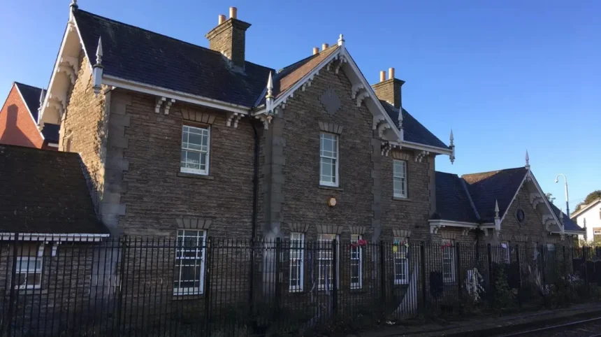
The station’s original name was Headingley and Kirkstall. Historical accounts record the development of the station and its changing relationship with the railway network. The original station building and platform are no longer used for regular passenger services, and the current platforms occupy a modified arrangement.
These physical changes illustrate how railway infrastructure evolved alongside passenger requirements. Stations were not static structures. Railway companies altered platforms, access points and operating arrangements as routes and services changed.
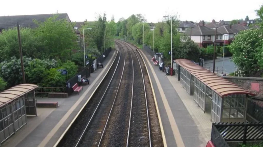
Headingley station remains on the Harrogate Line, which connects Leeds with communities to the north, including Horsforth and Harrogate. For visitors, this means the station serves both local journeys and wider exploration of West Yorkshire and North Yorkshire.
How Did the Railway Influence Headingley’s Residential Growth?
Railway access made Headingley more practical for people travelling regularly to Leeds for employment, education and shopping. Improved connectivity supported suburban growth, encouraged residential development along established routes and strengthened the district’s relationship with the expanding urban area.
During the nineteenth century, industrial employment attracted workers to Leeds, while improvements in transport expanded the range of places from which people could travel into the city. Headingley’s location outside the busiest central districts made it an important area within this wider pattern of suburban development.
Railway stations influenced residential geography because proximity to reliable transport reduced the inconvenience of daily journeys. Homes within walking distance of a station became more attractive to people who needed regular access to central Leeds. The railway also connected residents with employment opportunities beyond their immediate neighbourhood.
This process did not depend on trains alone. Road improvements, new housing, shops, schools and public services contributed to the district’s growth. Railway connectivity formed part of a wider system that made suburban living increasingly practical.
Historic maps help reveal these changes. Comparing maps from different periods shows the relationship between railway lines, roads, building plots and expanding residential streets. Historic Ordnance Survey mapping for Headingley includes editions from the nineteenth and twentieth centuries, providing a way to investigate how the district’s built environment changed.
As you explore the modern neighbourhood, you are crossing land shaped by generations of transport and residential change. Read the full [Headingley historical background and the development of the local neighbourhood] to understand how its older settlement evolved alongside railway expansion.
The relationship between transport and housing remains visible today. Residential streets, university accommodation, local businesses and sporting facilities sit within a district connected to Leeds by rail and road. The railway’s historical influence is therefore not confined to the station itself; it forms part of the wider pattern of development.
What Role Did Burley Park Station Play in Local Transport?
Burley Park station provides a second local railway access point close to Headingley, serving the Burley neighbourhood and surrounding residential areas. Its presence distributes passenger access across the district and supports journeys towards Leeds and destinations on the Harrogate Line.
Burley Park is important because a neighbourhood’s relationship with rail travel depends on the location of its stations, not simply on the presence of a railway line. A second station creates another point of access for people living, studying or working in nearby streets.
The station serves an area associated with residential housing, student accommodation and local amenities. Its position helps connect communities between central Leeds and Headingley, reducing the need for every passenger to travel to a single station.
The distinction between Headingley and Burley Park also matters for visitors. Headingley station is situated off Kirkstall Lane, while Burley Park serves the neighbouring Burley area. The most convenient station depends on the precise destination, walking route and scheduled train service.
Both stations sit within the broader Leeds–Harrogate railway corridor. Their value comes from connecting residential areas to the regional network, including Leeds city centre and northern destinations. Passengers should check the current timetable before travelling because not every train necessarily serves every station.
Burley Park also demonstrates how railway access can serve a changing population. Students, long-term residents, commuters and visitors use local transport for different purposes, but they share the need for reliable connections with other parts of Leeds.
For historical research, station development should be examined alongside the growth of surrounding streets and housing. The West Yorkshire Archive Service preserves documentary material relating to the region’s local history, buildings and communities, making it a useful starting point for investigating the railway’s effect on Burley and Headingley.
How Did Buses and Trams Complement Headingley’s Railway?
Buses and the wider Leeds public transport network complemented railway services by connecting neighbourhood streets with stations, shopping areas, workplaces and destinations beyond walking distance. These transport modes expanded local mobility and helped residents travel without relying exclusively on private vehicles or railway stations.
A railway station offers rapid movement along a fixed route, but it cannot serve every street directly. Local buses address this limitation by connecting residential areas with major roads, commercial centres and transport interchanges.
In Leeds, public transport developed through several stages, including horse-drawn road services, electric tramways and motor buses. Each mode served different needs. Tramways operated along designated urban routes, while buses provided greater flexibility in the streets and districts they served.
For Headingley, the interaction between rail and road transport helped connect residential streets with Leeds city centre. A passenger could walk to a bus stop, travel to a railway station or use a direct bus service, depending on the destination and timetable.
Trams also formed part of Leeds’s historical public transport development. Their significance lies in the expansion of urban passenger movement across the city, although individual routes and service dates need to be checked against historical transport records before assigning a specific tram route to a particular Headingley street.
Motor buses became an important part of local transport because they could serve routes that did not have railway infrastructure. They also connected people with destinations that required a journey beyond the immediate station area.
Today, buses and trains remain complementary rather than interchangeable. Rail provides connections along the railway corridor, while buses serve a broader network of streets and destinations. Walking and cycling complete the system by linking homes and attractions with stops and stations.
Visitors should compare the entire journey rather than choosing a transport mode based solely on distance. A train journey can be quick between stations, but the time required to reach the platform and walk from the destination station also matters. A bus can provide a more direct route for some journeys.
How Did Railway Development Affect Headingley’s Economy and Education?
Railway connectivity strengthened Headingley’s relationship with Leeds by making regular travel more practical for workers, students, shoppers and visitors. This accessibility supported the district’s role as a residential area and improved connections with employment, educational institutions, commercial services and regional attractions.
Leeds developed as an important industrial and commercial centre, creating demand for reliable transport between workplaces and residential districts. Headingley’s railway connection allowed residents to travel into the city while maintaining homes outside the central business area.
The railway also widened access to shops, cultural venues and public institutions. People living in Headingley gained a practical way to reach destinations across Leeds, while visitors from elsewhere gained another route into the district.
Education became an increasingly important part of Headingley’s identity. The University of Leeds and Leeds Beckett University’s Headingley campus contribute to the wider area’s student population and daily travel demand. The railway provides one option for students and staff travelling between residential neighbourhoods and other parts of the city.
However, the railway alone does not explain the area’s educational development. Institutional expansion, housing availability, road transport and the growth of Leeds all contributed to the district’s modern character.
Sport and leisure also benefit from transport connectivity. Headingley Stadium, known for cricket and rugby league, attracts visitors from across Leeds and beyond. Rail and bus services offer alternatives to driving, although event-day travel requires attention to service schedules, walking routes and crowd conditions.
Local businesses benefit when customers and employees can reach an area through several transport modes. Pubs, cafés, shops and other services depend on the combined effects of local residents, students, commuters and visitors.
These relationships demonstrate the economic significance of transport infrastructure. A railway does more than move passengers between two points. It influences where people live, how they access services and which neighbourhoods become convenient places for business, education and recreation.
How Did Railway Services Change During the Twentieth Century?
During the twentieth century, Britain’s railway network experienced changes in ownership, passenger demand, infrastructure and operating practices. Headingley remained connected to the Leeds railway network, while broader national changes influenced service patterns, station facilities and the role of trains in everyday local transport.
The early twentieth century brought continued changes to railway operations across Britain. Railway companies consolidated, infrastructure was adapted and passenger services evolved alongside road transport. Headingley’s railway history reflects these national developments as well as the specific needs of the surrounding population.
The grouping of railway companies during the early twentieth century changed how many lines were operated. In 1923, the Railways Act 1921 led to the formation of four major railway companies in Great Britain. The London and North Eastern Railway became responsible for many routes previously operated by constituent companies in northern England.
Nationalisation followed in 1948, when the mainline railway network became part of British Railways. This brought railway operations under public ownership and formed part of a wider reorganisation of Britain’s transport system.
The growth of private car ownership and road-based transport changed passenger travel during the post-war decades. Across Britain, railway operators reviewed routes, services and facilities in response to changing demand and financial pressures.
These national developments affected the context in which local stations operated. However, changes to an individual station’s services should be established from local timetables and historical records rather than inferred solely from national policy.
Headingley’s railway history also includes physical alterations. Historic photographs document the station in different periods, including images from 1960, while historical local research records changes to station buildings and railway infrastructure.
Studying these changes helps explain why today’s station differs from its nineteenth-century form. Platforms, passenger facilities and access arrangements have evolved, while the railway corridor has retained its importance within Leeds’s transport network.
What Is the Difference Between Headingley’s Historic Railway and Today’s Network?
Headingley’s historic railway developed through nineteenth-century railway construction, whereas today’s network operates within a modern passenger transport system. The route retains its regional role, but contemporary services, station accessibility, ticketing and passenger information reflect later operational and technological changes.
The historic railway served a transport environment in which journeys depended heavily on scheduled trains, station staff and printed timetables. Passengers planned travel around published departure times and the connections available at the time.
Modern railway travel uses digital information, electronic ticketing options and updated accessibility facilities. These changes affect how passengers plan journeys and navigate stations, although the basic function of moving people between destinations remains the same.
Headingley station’s current facilities illustrate this transition. National Rail lists step-free access to all platforms, lifts, ticket machines, customer information screens and bicycle storage. The station also has a sheltered waiting area and a small car park.
These features serve contemporary passenger needs that differ from those of the station’s nineteenth-century users. Step-free access improves movement for passengers with mobility requirements, while real-time information helps travellers respond to service changes.
The current station is also connected to a wider network of buses and other local transport options. Passengers can plan journeys that combine rail with walking, cycling or bus travel, depending on their destination.
Historical comparison reveals both continuity and change. The railway corridor remains an important part of Headingley’s connection with Leeds, but the way passengers access information, buy tickets and use station facilities has changed substantially.
Visitors interested in transport history should observe the station’s setting as well as its present-day equipment. The relationship between the platforms, surrounding roads and nearby housing reveals how a nineteenth-century transport facility continues to operate within a modern urban neighbourhood.
How Can Visitors Explore Headingley’s Railway History Today?
Visitors can explore Headingley’s railway heritage by examining the station, tracing historic transport routes and comparing old maps with the modern street layout. Combining a short railway-focused walk with visits to nearby neighbourhood landmarks provides a practical way to understand the relationship between transport and urban development.
1. Visit Headingley station
Start near Kirkstall Lane and observe the station’s position relative to the surrounding streets. Look at the railway corridor, access points and nearby buildings to understand how the station fits into the neighbourhood.
2. Compare Burley Park station
Continue towards Burley Park to examine another local railway access point. Comparing the two stations helps explain how railway access serves different residential areas within the wider district.
3. Observe the surrounding streets
Look at the relationship between older buildings, residential streets and the railway. The present layout reflects successive phases of development rather than a single period of construction.
4. Compare historic maps
Historic Ordnance Survey maps provide evidence of how roads, buildings and railway lines appeared in different periods. Maps of Headingley from 1847 and later editions offer useful starting points for comparison.
A self-guided visit works best when the railway is considered as part of the wider neighbourhood. The station alone cannot explain the full history of local transport. Its relationship with roads, residential buildings and nearby destinations provides more context.
Visitors should check current train times before setting out and use designated pedestrian routes. Railway tracks and operational infrastructure are not public walking routes, and access restrictions must be respected.
For a broader heritage visit, combine the railway area with Headingley’s village streets, historic buildings and sporting landmarks. This approach demonstrates how transport helped shape the district’s wider identity.
Explore More Area Guide
Headingley Former Cinemas: The History of Leeds Entertainment
Headingley Historic Pubs: Stories Through the Years in Leeds!
Where Can Researchers Find Reliable Records of Headingley’s Railway History?
Reliable research into Headingley’s railway history draws on historic maps, archival documents, station records, photographs and local heritage publications. These sources help establish dates, identify former railway structures and compare historical transport arrangements with the modern neighbourhood.
The West Yorkshire Archive Service preserves historical documents relating to communities, buildings and regional development. Its collections provide a starting point for researchers investigating local history, railway records and the development of Leeds’s surrounding districts.
The Thoresby Society also maintains historical material relating to Leeds, including map and plan catalogues. Its records include nineteenth-century mapping associated with Headingley-cum-Burley, offering evidence of the area’s landscape and land use before later urban expansion.
Historic Ordnance Survey maps are particularly useful because they record physical features at different dates. Comparing an early map with a later edition helps researchers identify changes in railway alignments, road connections and the density of buildings. Historic map collections include Headingley editions from the nineteenth and twentieth centuries.
National Rail provides current station information, including facilities, accessibility and passenger services. It is useful for understanding how Headingley station operates today, but current station information should not be treated as a complete historical record.
Local heritage publications can add context through historic photographs, station descriptions and accounts of railway development. Where a publication gives a specific opening date, closure date or service change, researchers should compare it with contemporary timetables, company records or archival evidence.
A strong historical account separates documented facts from interpretation. Station opening dates and recorded infrastructure changes are factual claims. Explanations of how railways influenced housebuilding, employment or travel patterns require evidence from multiple sources.
Using these sources together creates a more complete understanding of Headingley’s railway heritage and its continuing relationship with Leeds.
Why Does Headingley’s Railway History Still Matter Today?
Headingley’s railway history remains relevant because the district’s present-day accessibility, residential character and visitor economy developed partly through improvements in transport. The railway continues to connect local communities with Leeds, while historic infrastructure helps explain the area’s growth and its place within the wider city.
Transport history provides context for understanding why Headingley developed as a residential and educational district. The railway made regular journeys into Leeds more practical and linked the neighbourhood with a wider regional network.
The continued presence of Headingley and Burley Park stations also demonstrates the enduring value of local railway access. Their locations help distribute passenger journeys across nearby residential areas and connect them with destinations beyond Headingley.
For commuters, rail provides an alternative to driving into the city centre. For students, it connects residential areas with educational and employment opportunities. For visitors, it offers access to Headingley and its attractions without requiring a car for the entire journey.
The wider transport network also remains important. Buses, walking and cycling connect homes and destinations with railway stations, while road infrastructure supports journeys that do not fit conveniently within the rail network.
Future transport decisions will continue to affect how people access Headingley. Passenger demand, service frequency, accessibility, station maintenance and connections with other transport modes influence the practical usefulness of the railway.
Understanding the past helps explain the present without suggesting that the district’s development followed a single cause. Railway investment worked alongside housing construction, economic growth, educational expansion and changes in public transport.
Headingley’s railway history is therefore more than a record of trains and station buildings. It is an account of how transport infrastructure helped connect a former village with a growing industrial city and how that connection continues to shape everyday travel across Leeds.
When did Headingley railway station open?
Headingley railway station opened in 1849 on the Leeds and Thirsk Railway. It improved connections between Headingley and Leeds, supporting local travel and the area’s later residential development.